Disclaimer: Any views expressed by individuals and organisations are their own and do not in any way represent the views of The Heritage Portal. If you find any mistakes or historical inaccuracies, please contact the editor.
By chance, two deltiologists meet. Initially, unbeknown to each other, they share the same collecting interest, namely picture postcards from the Transvaal-based town of Middelburg. Ironically, today, they only stay some five kilometers from each other.
Rex collects Middelburg postcards because of him having resided in Middelburg in his younger adult years. He was also the mayor of Middelburg in the early 1990s. Carol on the other hand collects Middelburg as part of a larger historical Transvaal-themed research collection.
We agreed to combine our collections to present a richer historical visual narrative of this town which was established as early as 1866. This article then also becomes the third in a series on old Transvaal towns relying on picture postcards of old (between 1900 and 1920s). The first two articles were on the towns of Heidelberg (click here to read) and Standerton (click here to read).
The photographic picture postcard was mainly in use between 1900 and the 1920s resulting in the visual history of this, and future Transvaal towns on which articles are pending, being restricted to a period of 20 years.
This article also does not portray the full visual history for this period as the historical narrative presented below was determined by the 100-year-old Middelburg picture postcards available between the two collections.
The postcards included in this article are therefore by no means a complete representation of postcards produced on Middelburg before 1920.
Middelburg had the honour of having a little booklet, containing some early picture postcards on the town itself, produced by Frewin as early as 1975 already.
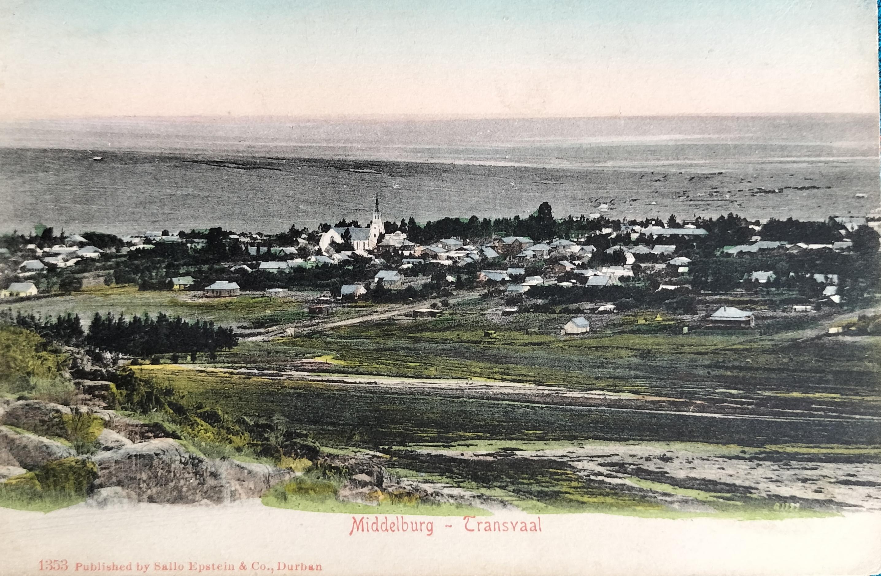
General view over Middelburg (from a westerly direction). This image was taken from Golfsig and shows the Wit Kerk and the then town centre. Card published by Sallo Epstein (circa 1904). Hilligan Collection
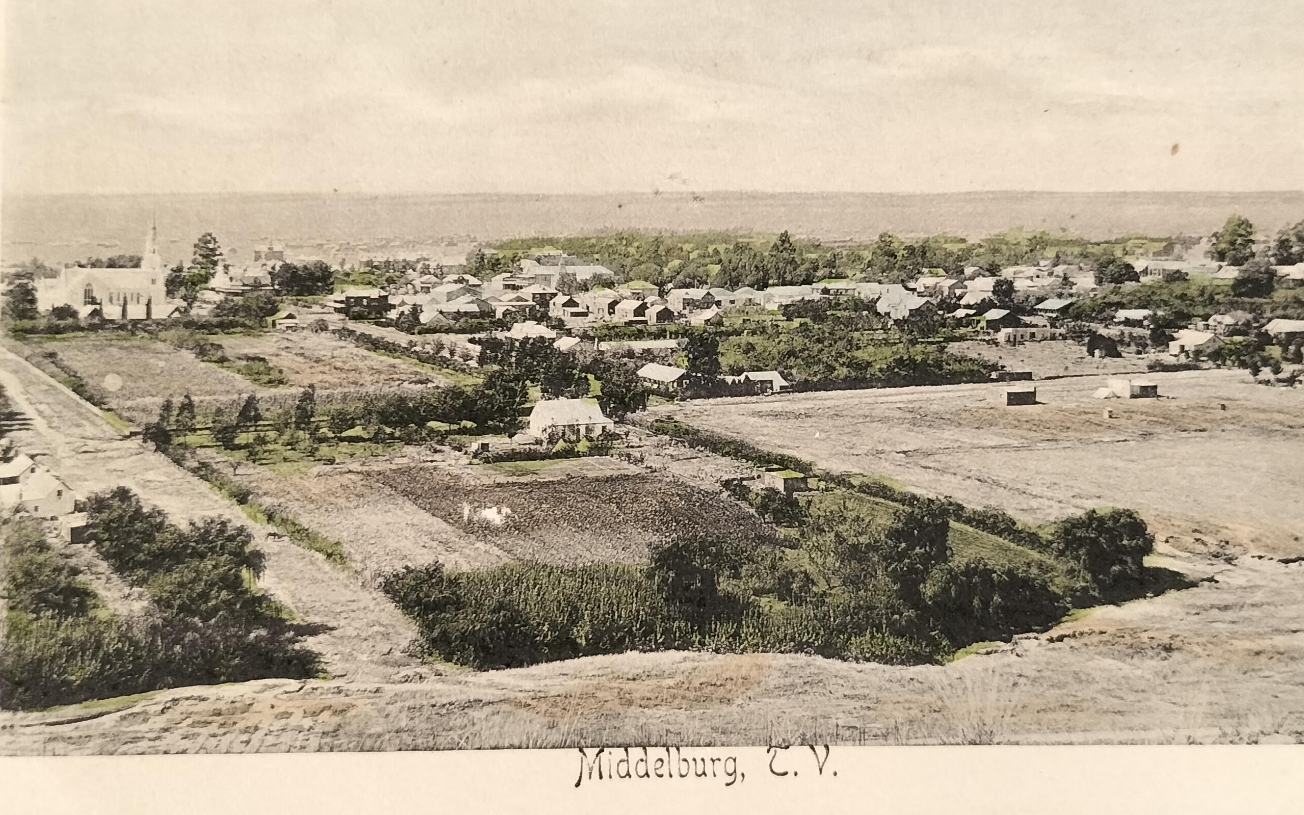
General view over Middelburg (from a westerly direction). The Wit Kerk is clearly visible. Not so visible is the Reformed Church just to the right of the Wit Kerk Tower. Card published by Middelburg-based photographer Frenzel (circa 1902). A note on the card describes the town as “Nothing more or less than an overgrown village.”
1. Brief history of Middelburg
The town Middelburg, situated next to the Klein-Olifantsrivier in the old Transvaal (Mpumalanga today), is not to be confused with the Middelburg in the Eastern Cape which had an earlier start (1852). Middelburg (Mpumalanga) today forms part of the Steve Tshwete Local Municipality (within the larger Nkangala District Municipality).
Reverend J.H Neethling of Stellenbosch visited the area in the 1850s and recommended a town be proclaimed and named Middelburg. As a result, Middelburg was planned as an ideal halfway point between Pretoria and the gold-mining town of Lydenburg in 1859. The farms Klipfontein and Keerom were relinquished by the then Government (Volksraad) to be developed as a new town, but the location of the proposed town did not appeal to surrounding residents resulting in the initial plan falling through. On 28 January 1864, the Dutch Reformed Church of Lydenburg bought the farm Sterkfontein from Lodewyk de Jager, following which the town Nazareth was established on it on 25 October 1864. On 25 February 1867, the Dutch Reformed Church Lydenburg formally relinquished the farm Sterkfontein, to the church council of Nazareth. Reverend Leon Cachet proposed the name Nazareth. Ten years later, on 23 October 1874, Nazareth was renamed to Middelburg (other sources fluctuate between the years of 1871 and 1872 in the renaming).
The area where the town is situated was originally part of the Lydenburg Republic which separated from the Zuid Afrikaansche Republiek (ZAR) in 1857. In 1860 the Volksraad of the Lydenburg Republiek determined that the name of the future district should be Middelburg. In the same year, only three years after separating from the ZAR, the Lydenburg Republiek was reincorporated into the ZAR again.
The size of the town, located between the farms of Ocker Jansen van Vuuren and MJ Herbst at the time, was determined from the middle point of the proposed town, one hour by horse in each direction (the size of two farms). The town was measured by the land surveyor Theodore Rooth (after whom Rooth Square was named). The then government received one-third of the stands of this new town. The first recorded resident was then also Theodore Rooth who built the first house in Middelburg as early as 1865. The second building to be erected was the small Dutch church in 1867. This building stood where the Pavilion or Middelburg Hotel stood.
A Middelburg shop owner, the Englishman JW Henwood, who arrived in Middelburg from London on 27 May 1879, had the following to say about the town where he elected to settle:
Of the people who lived here in the early days, I can only speak of them with the greatest respect and admiration – in fact, the genuine hospitality and friendship I have received from the Africander (sic) can never be forgotten.
At the time of the town being established, residents had no idea that their surroundings were rich in coal deposits.
Today, Middelburg is well known as the Stainless-Steel Capital of Africa.
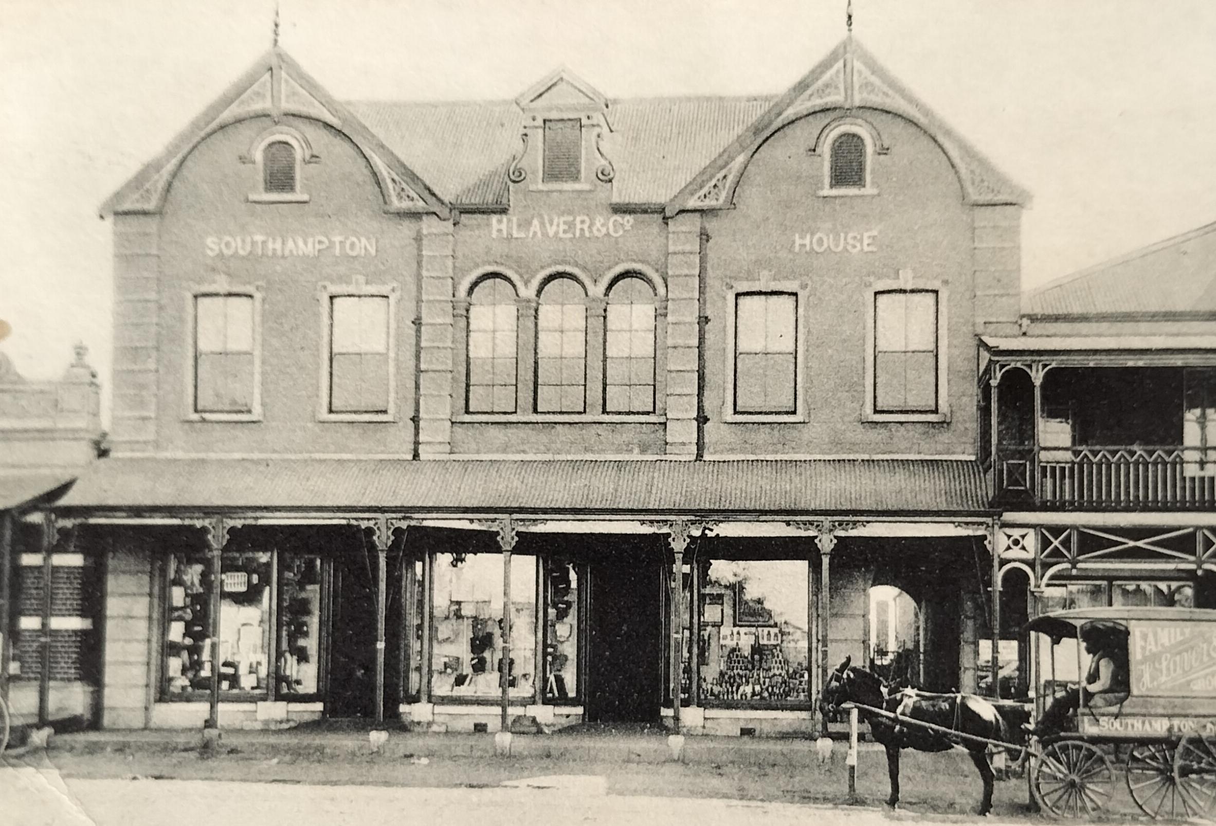
H. Laver & Co grocer's store in the Southampton House on Church Street facing Church Square. The proprietor Joseph Henry Laver (1863 – 1938) named this building after his place of birth – Southampton. Laver Senior was a mayor of Middelburg between 1907 and 1909. His son, Harry Laver, an accountant, was also the mayor of Middelburg on 10 instances between 1925 and 1952. Note the Laver marked delivery wagon in front of the store. Card published by Raphael Tuck & Sons (circa 1904).
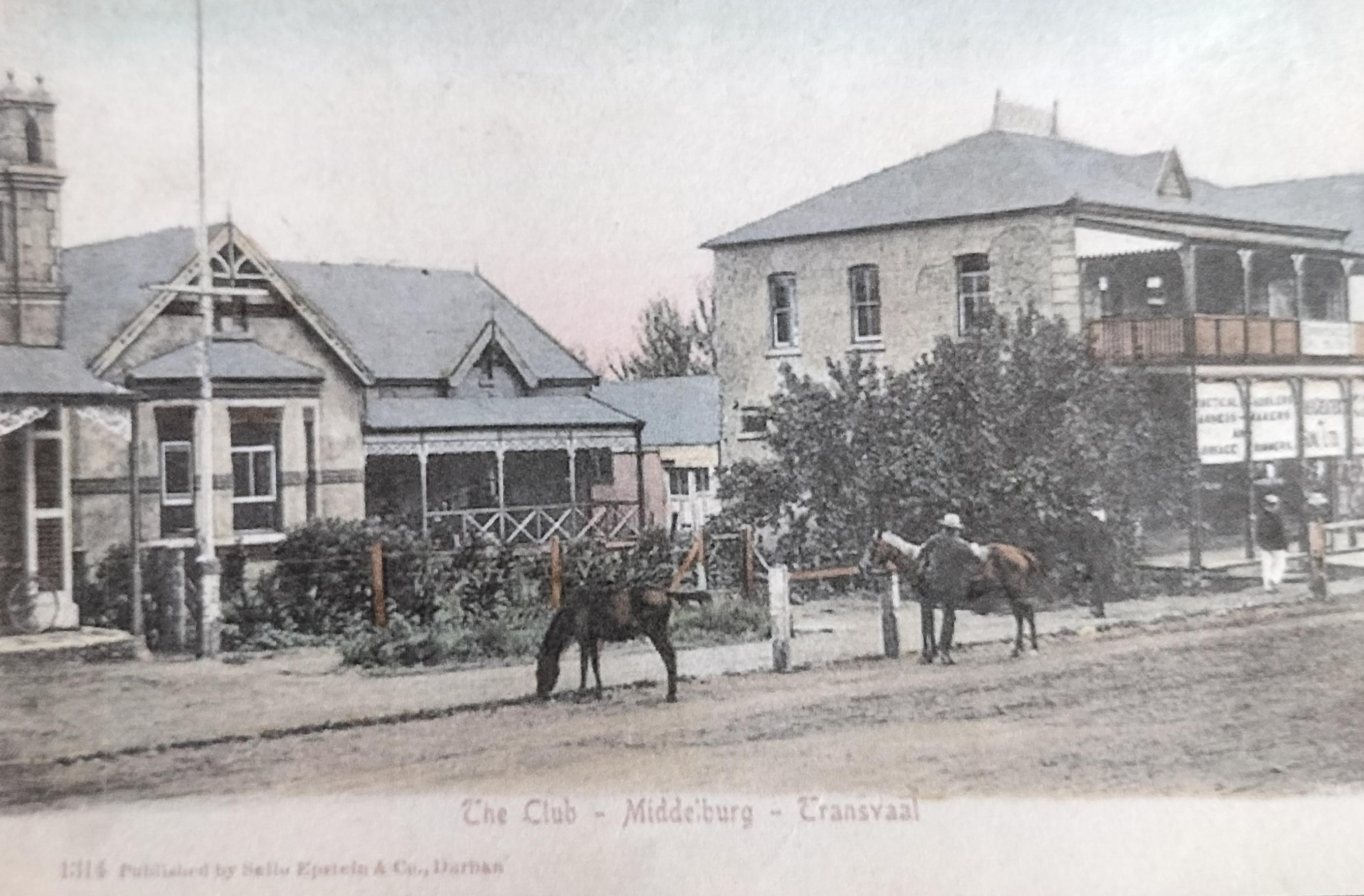
The Clubhouse on Church Street in Middelburg. It is located two buildings up from the business H. Laver. Note the hitchrack in front of the Club. Card published by Sallo Epstein (circa 1905). Hilligan Collection
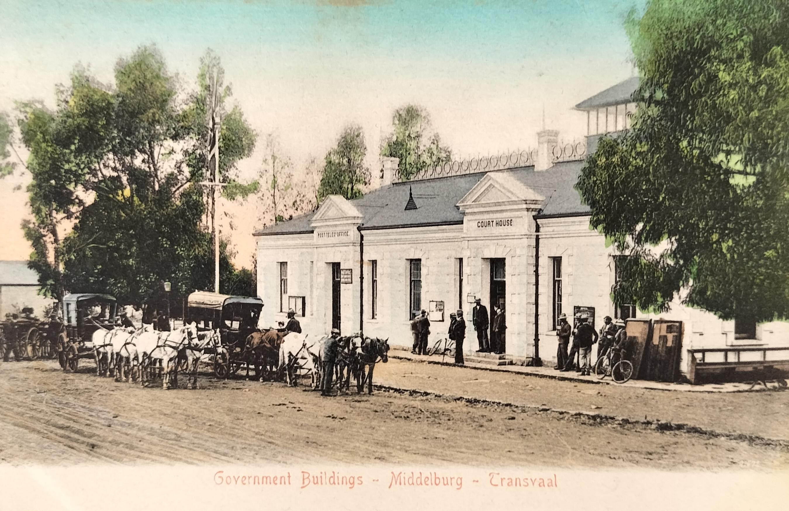
Original courthouse and Post Office on Market Street (OR Tambo Street today) before burning down in March 1907. Card published by Sallo Epstein (circa 1907).
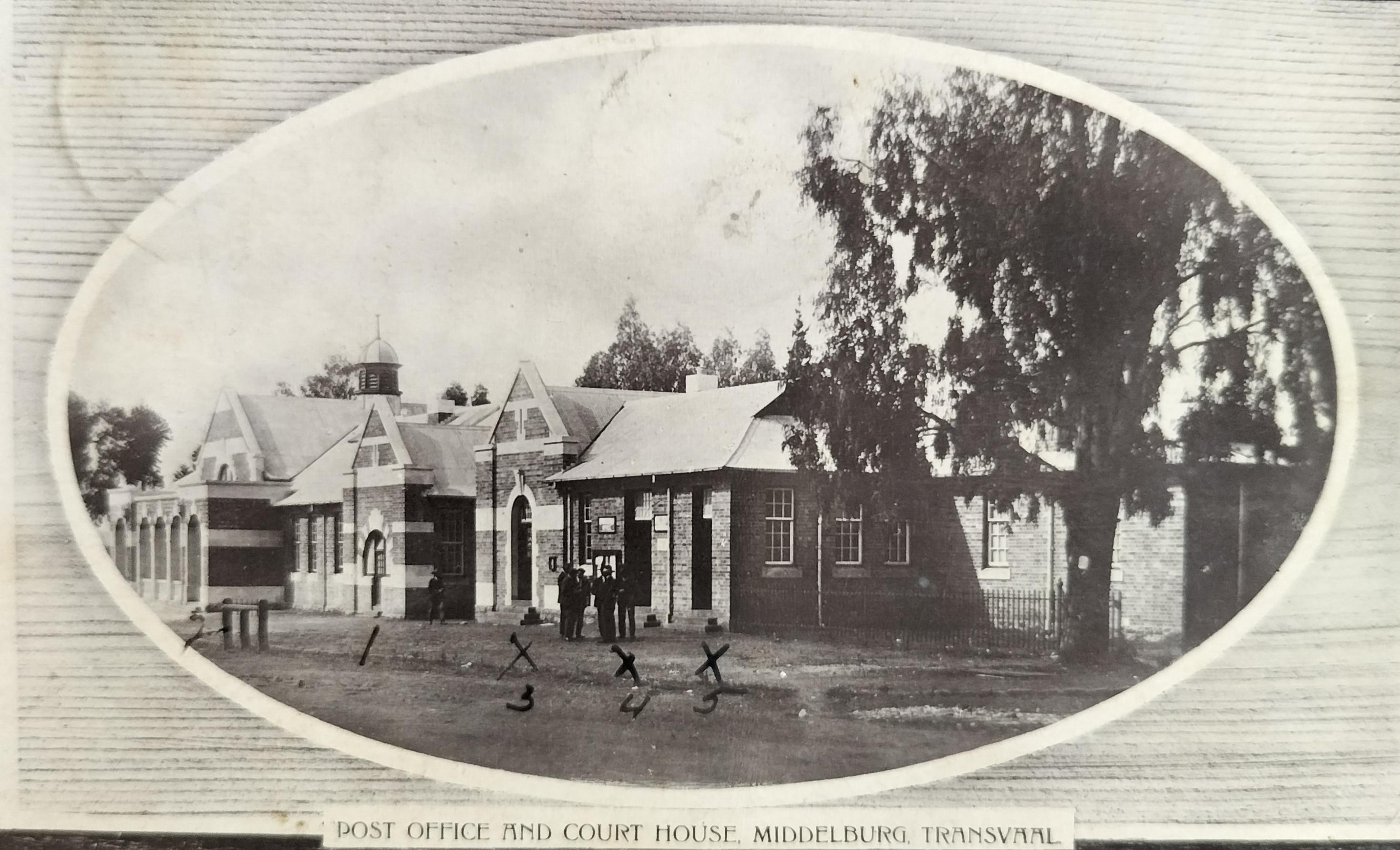
After the complex burned down in 1907, the cornerstone of the new complex was laid in September 1908. The first building on the far left is the Court House (number 2 on the card), followed by The Revenue Office (number 1 on the card), followed by, what is described on the card as a private hall (number 3 on the card) and the two entrances to the Post Office (numbers 4 and 5 on the card). Another source suggests that the hall (number 3) actually contained private post boxes and the mail sorting room. Card published by Middelburg Stationary Company (circa 1915). Hilligan Collection
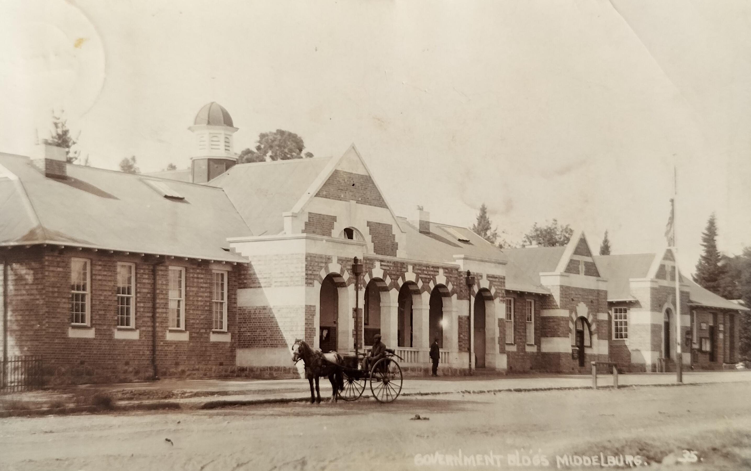
Government buildings, Market Street, which consisted of the Court House and Post Office, were completed in 1909 after the previous complex burned down (see image above). Card by SAPSCO (circa 1911). Today this complex acts as a regional High Court.
2. Middelburg during the Anglo-Boer Wars
Middelburg was not affected by the First Anglo-Boer War.
The impact of the Second Anglo-Boer War on town was however significant in that some nine hundred men from the district were commandeered to defend their country against the British in Natal. The British in turn took Middelburg in July 1900.
A fortified blockhouse was built by the British on Kanonkop (just outside town) to guard against Boer attacks from the north. The blockhouse was equipped with a searchlight, powered by a kerosine generator that swept the town at night to enforce the curfew.
Attempted peace negotiations took place between General Louis Botha and Lord Kitchener on 28 February 1901 in the garden of Highbury Hall in Church Street – the home of Joseph Henry Laver. One source suggests that the house was commandeered by General Lyttleton as the British headquarters at the time, whilst a more credible source suggests that Laver made the house available to British when he returned to England with his family.
The British built the largest concentration camp in Transvaal in Middelburg during the Anglo-Boer War, reaching over seven thousand inmates at one point. Reports by Dr Kendal Franks and the Ladies Committee suggested that the concentration camp was very badly run. Dr Franks was critical of the layout of the camp and complained that the administration was ‘lax,’ while the Ladies Committee thought it ‘one of the most unsatisfactory we have seen.’ An intake of over 3000 women and children in May 1901 brought in desperately impoverished and debilitated people, which precipitated disease. A Memorial Hall was built for the 1381 women and children who died in the concentration camp at the time. This Hall currently stands on the Middelburg Technical High School grounds.
Black labourers, captured from surrounding farms, were brought to a smaller black concentration camp (with some 451 residents) which is thought to have been located adjacent to the Mhluzi neighbourhood.
Following the Anglo-Boer War, the British remained in the military cantonments in town. It has been suggested that three thousand British soldiers were stationed in Middelburg at one point. With the presence of the British, the town experienced an economic boost (five hotels were thriving in town at the time), but after the military departed in 1909, the town withered.
One interesting urban legend relates to that of a small group of burghers that were facing canon fire by 45 British canons on Dalmanutha. Facing the ruthless bombardment, the burghers elected to flee. One soldier however elected to remain behind and kept on firing at the British. When eventually cornered by the British, they found it to be a 14-year-old boy who stood his ground. So impressed were the British with the young man’s bravery that they loudly applauded him. Sadly, the name of this brave young man, who was taken as a prisoner-of-war, remains unknown.
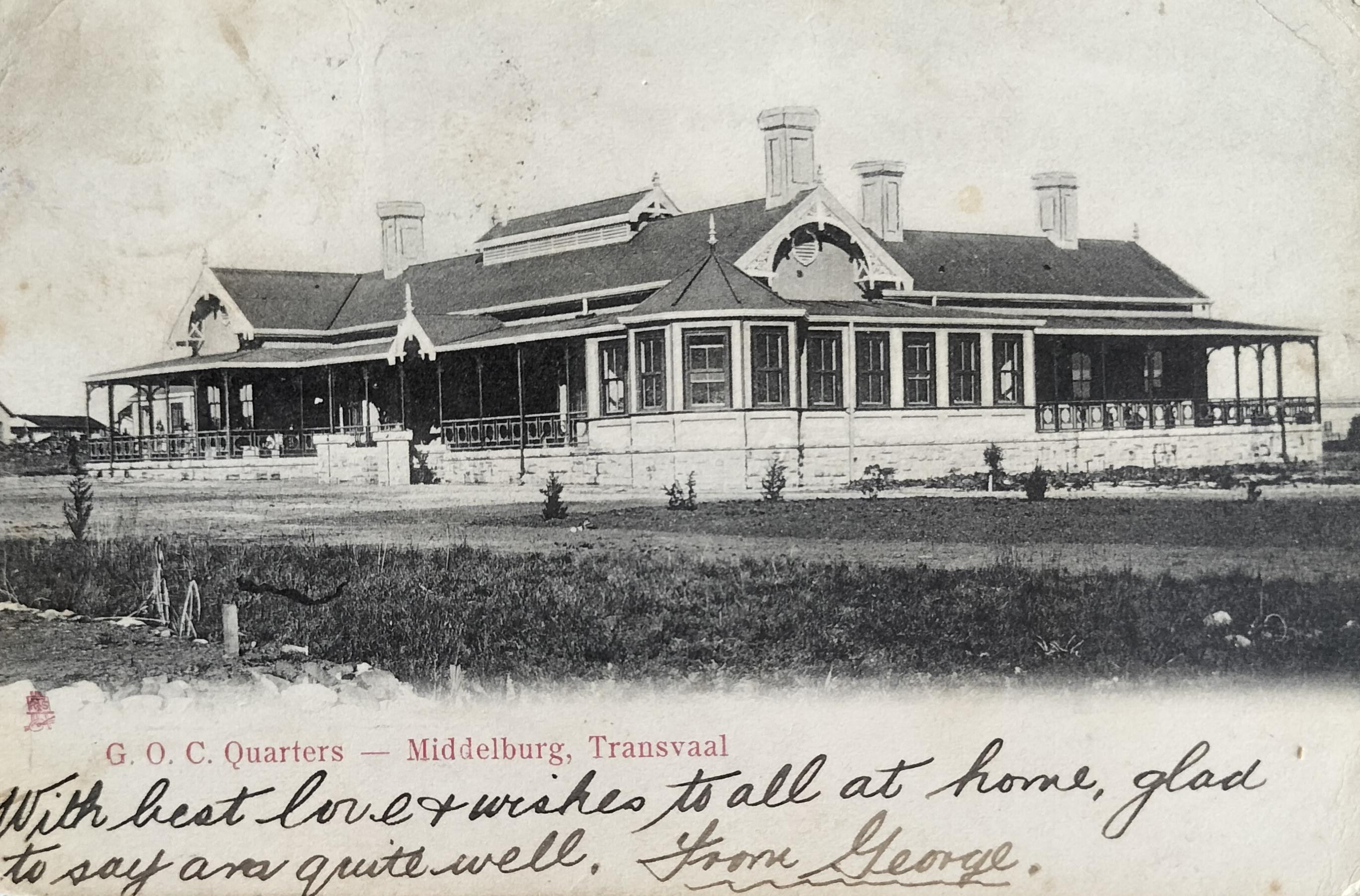
General Officer Commanding (GOC) Quarters in Middelburg which was located in what is Clubville today. Card published by Raphael Tuck & Sons (circa 1903). Hilligan Collection
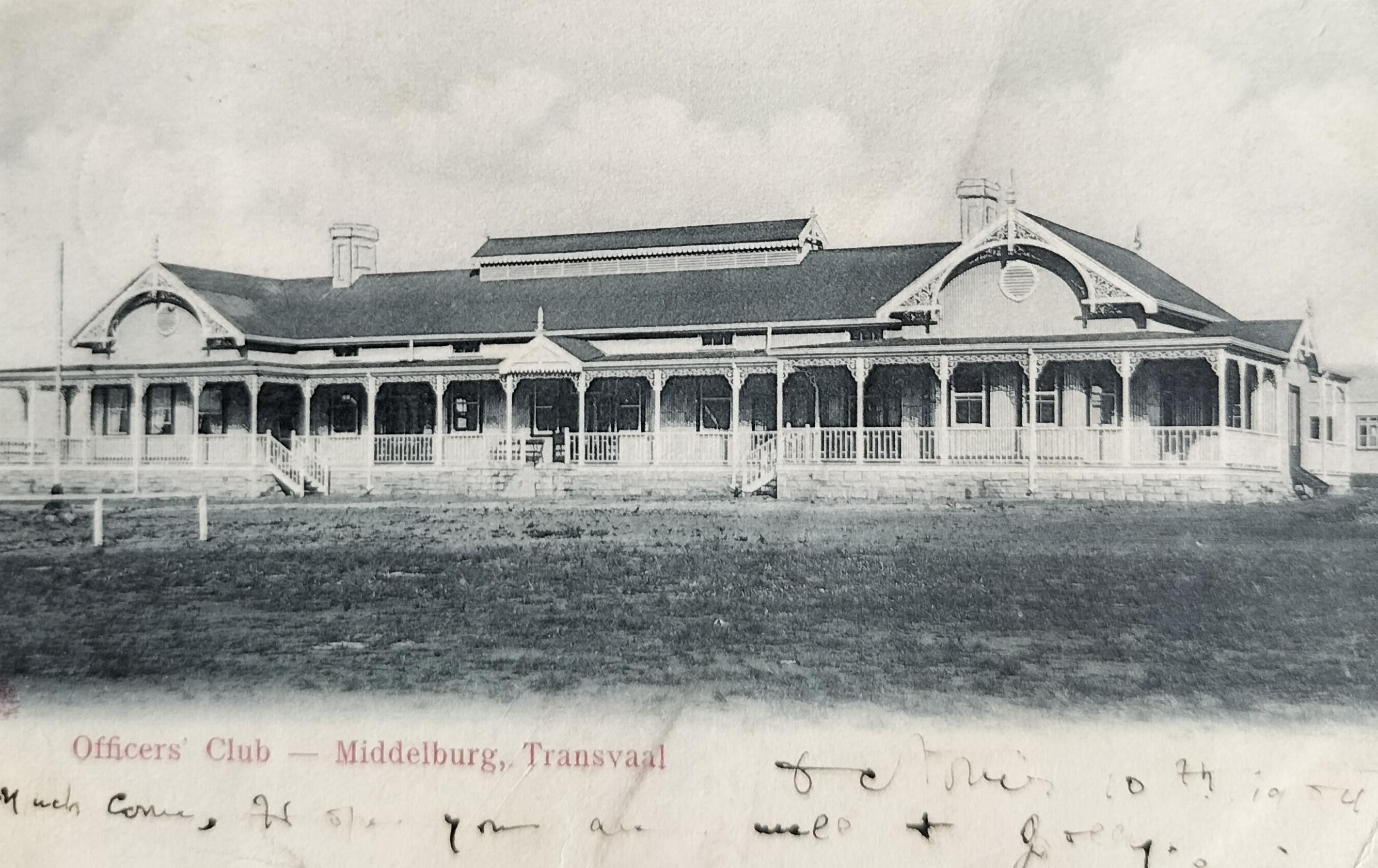
Officers Club in Middelburg. Card published by Raphael Tuck and Sons (circa 1903). Hilligan Collection
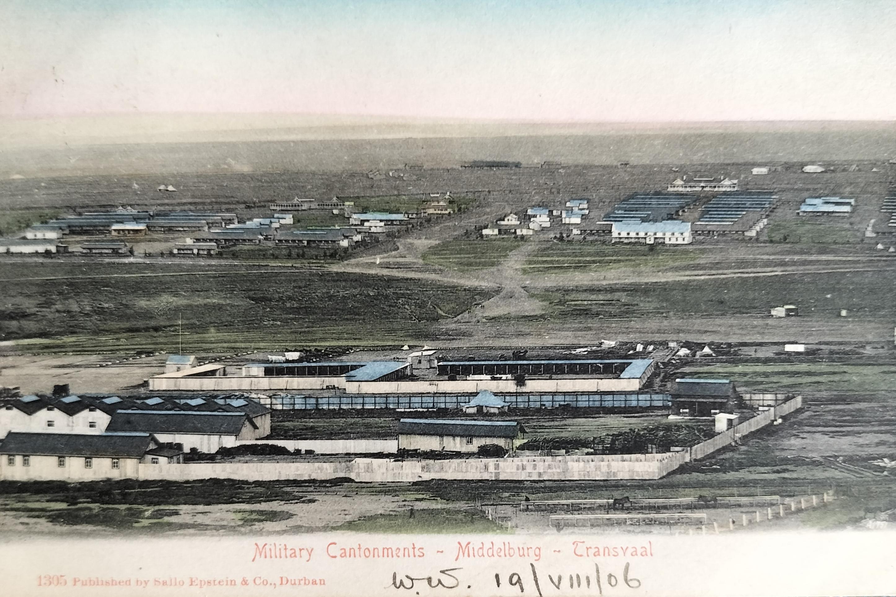
Military Cantonments in Middelburg which was located where the golf course is today. Card published by Sallo Epstein (circa 1903). Hilligan Collection
Military Cantonments in Middelburg which was located where the golf course is today. Card published by Sallo Epstein (circa 1903). Hilligan Collection
3. Railway Station
Although it has been suggested that the Middelburg station was built using the same building plans as the Middelburg station in the Netherlands, this turned out to be fiction as there are no similarities between the two buildings (Ligthelm,2024).
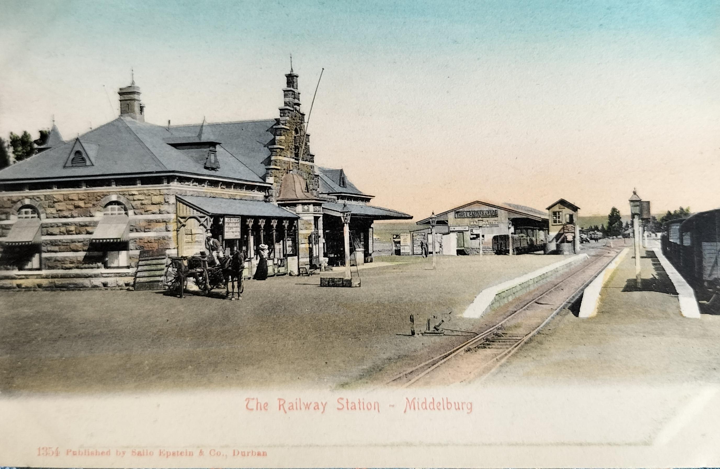
By the time the railway reached Middelburg, the town had already become an agricultural centre of importance and was the hub of transport roads. The station was expected to become important because of the nearby coalfields. For this reason, much more care went into the design and construction of the station building. The station building became one of the NZASM’s masterpieces in terms of railway architecture. The building contained offices, waiting rooms, a bar and living quarters for the station master. It was constructed of red sandstone, with alternating bands of white sandstone.
The Middelburg station complex, one of twenty-four station buildings planned between Pretoria and the Mozambique border (the sixth station from Pretoria), was completed in 1895. The building was situated on the open ground more than one kilometre east of the town. The reason for the station’s location so far out of town was that there were plans to expand the town in an easterly and a southerly direction at the time. Passengers initially were not happy with the location due to the extra time and cost to travel to and from the railway station.
The architect was the NZASM architect Victor Alexander Herman Claudius van Lissa.
Although unknown who the building contractor was, de Jong, van der Waal & Heydenrych (1988) suggest that the building may have been erected by Meischke, who was experienced in building sandstone railway structures.
The line was officially opened on 2 November 1894, with the first train passing through the end of October or early November 1894, even before the station building was completed.
Unlike the original station building in Standerton, this building has survived and today is a national monument.
The station also played a significant role during the Anglo-Boer War (1899-1902).
It is known that Kruger would have passed through Middelburg enroute to Lourenço Marques. It has also been suggested that Churchill, following his escape from Pretoria, would have passed through the station hiding on a freight train heading east.
The Middelburg Railway Station. This complex, completed in 1895, stood one kilometre outside town. Note the ladder against the front light pole. This suggests that the paraffin-operated light had to be manually lit every night. Card published by Sallo Epstein (circa 1905).
4. Religious activity
In Middelburg, the three-sisters churches as they are known today — Nederduitsch Hervormde Kerk (NHK), Gereformeerde Kerk (GK) and the Nederduitse Gereformeerde Kerk (NG), were all established in town before the turn of the century.
4.1 Nederduitse Gereformeerde Kerk (NG) – Wit Kerk:
After the NG Church of Lydenburg bought the farm Sterkfontein from Lodewyk de Jager, the congregation of the NG Church, Nazareth, was established on 25 Feb 1867.
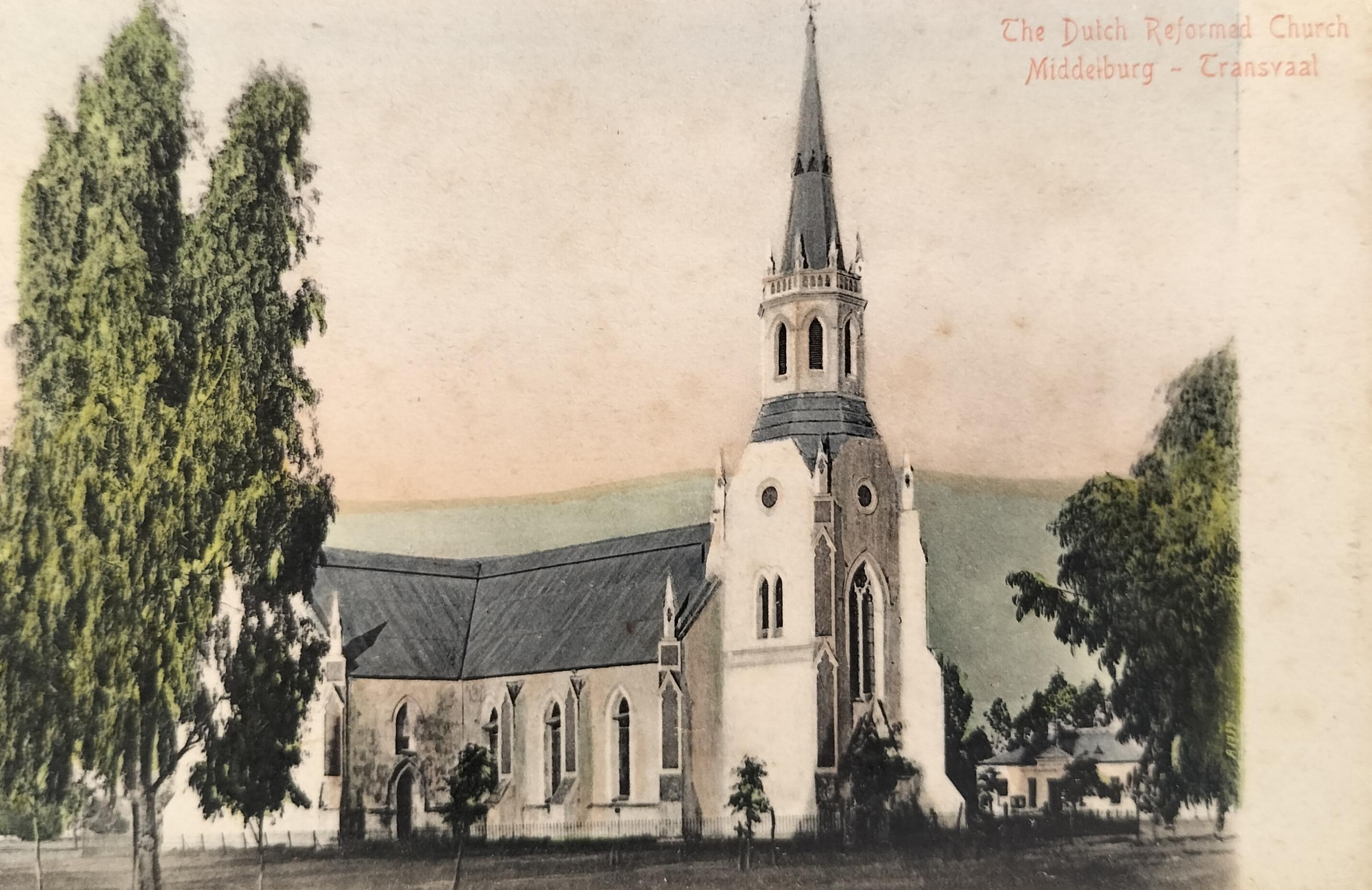
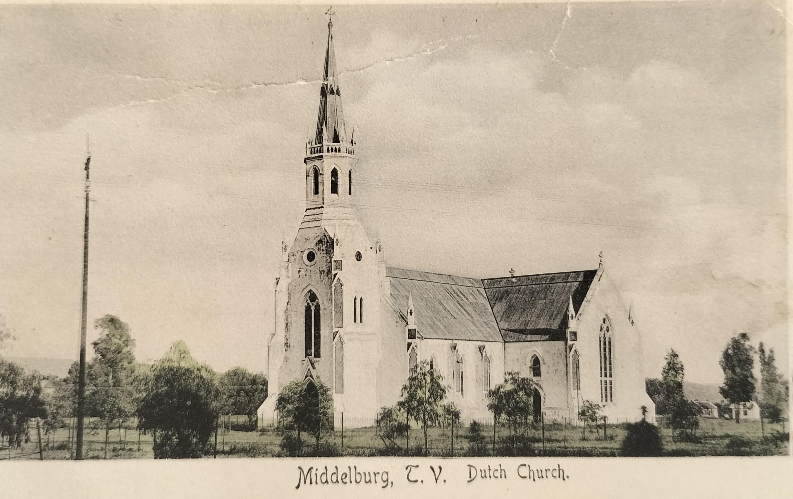
Their first building was a small, thatched roof building, built in 1869. The church complex that replaced the initial thatched roof complex has become an iconic landmark of Middelburg facing the original Church Square (renamed to Rooth Square and later to van Blerk Square). The cornerstone of the church was laid on 2 April 1887 and inaugurated on 18 January 1890. The church was designed by Carl Otto Hager, who was also a significant early (1850/60s) Cape Town-based photographer. This picture-perfect White Church, built in a Cape Gothic style, is also the oldest surviving church building in the town. The Octagonal tower, very intricate and crown-like, is topped by a tall grey iron spiral. It has been suggested that Hagar started building the church before his son took over to complete the task.
The impressive church organ is also a port of call on Middelburg’s contemporary spooky ghost tours where it is claimed the organ can be heard each year at midnight on the 18th of December.
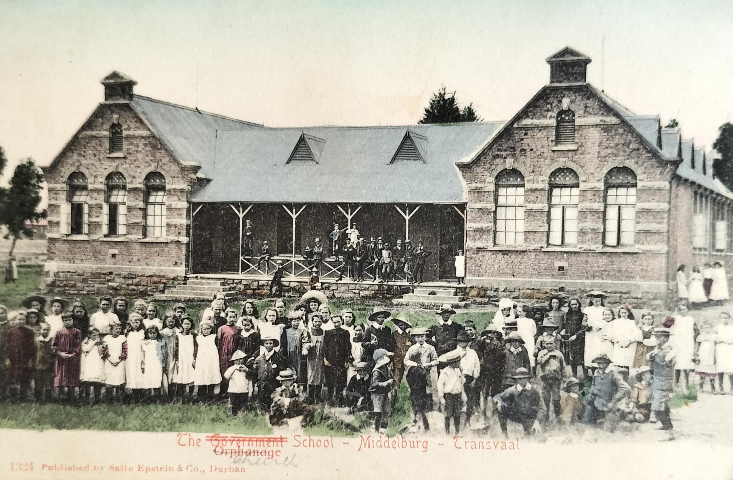
The church bought a house in the middle of town, across from the market square. On 5 December 1902, an orphanage (starting with forty-five orphans) was established for children who were left without parents following the Anglo-Boer War. The orphanage expanded rapidly in that in 1904 a bigger orphanage had to be considered – the Excelda Orphanage. The orphanage only remained in Middelburg until 1908 whereafter children were placed at the Abraham Kriel orphanage.
The Dutch Reformed Church (Wit Kerk) in Middelburg. This oldest surviving church in Middelburg was inaugurated on 18 January 1890. The architect was Carl Otto Hagar (1813 -1898), who was also the architect of several other churches in South Africa. Hagar was also one of South Africa’s earlier Cape Town-based photographers. In the background part of the courthouse can be seen. Card published by Sallo Epstein (circa 1905).
The Dutch Reformed Church (Wit Kerk) in Middelburg was photographed from a different angle than the above. Note the telegraph pole on the left of the image. Card published by Middelburg-based Frenzel who is also recorded as having been a photographer in town (circa 1903).
4.2 Other Churches in town
Although the listed churches below may not be a complete representation of the period 1866 to 1920, or an entirely correct representation, they included:
- The Gereformeerde Kerk (GK): was established on 25 October 1890 with the cornerstone of their church complex being laid on 14 June 1890. This initial church building was based on the corner of Coetzee and Voortrekker Streets.
- The Nederduitsch Hervormde Kerk (NHKA). The first Church, a corrugated iron building, was built in 1876. This building, which stood in Market Street opposite the Market Square, was later replaced by a second building (1896) due to termite damage to the first building.
- Synagogue: Middelburg once had a strong Jewish presence. Although the synagogue on Coetzee Street (Johan Magagula Street today) is no longer in use as a religious building, it was built in 1914. The foundation stone of the Synagogue was laid by Rabbi JL Landau on 12 August 1914.
- Presbyterian Church (Holy Trinity Church): The Presbyterian community was already active in town as early as 1872. The cornerstone of their first church building, based in Long Street, was laid in 1904. OH Frewin, owner and publisher of the Middelburg Observer, was the organist at this church for 40 years.
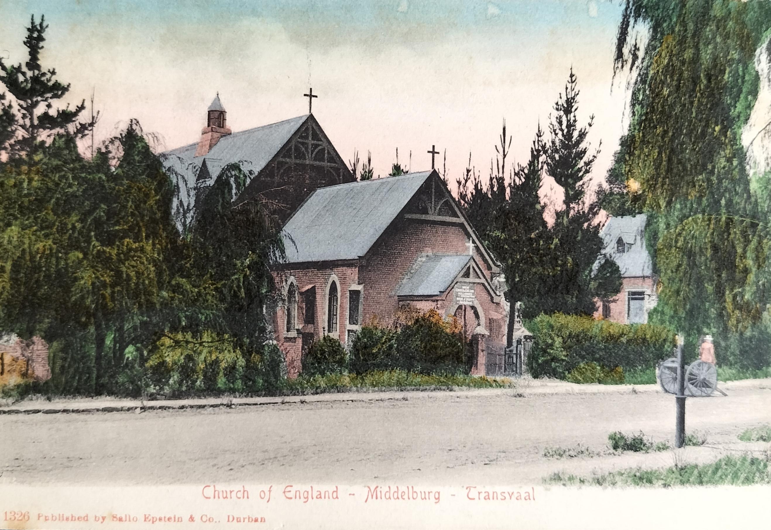
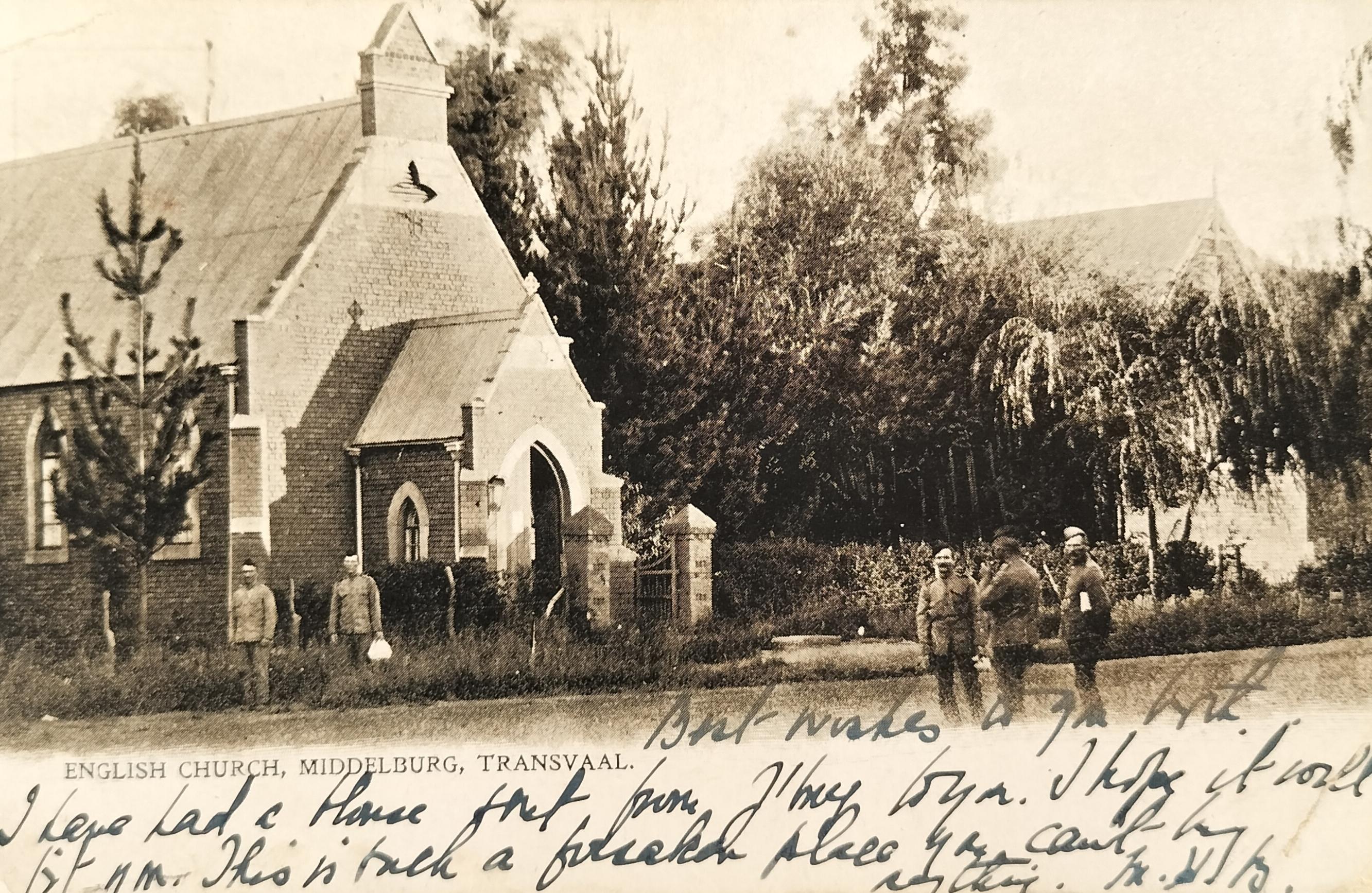
- The English Church (Anglican): Established in 1879, the first church building was erected in 1887.
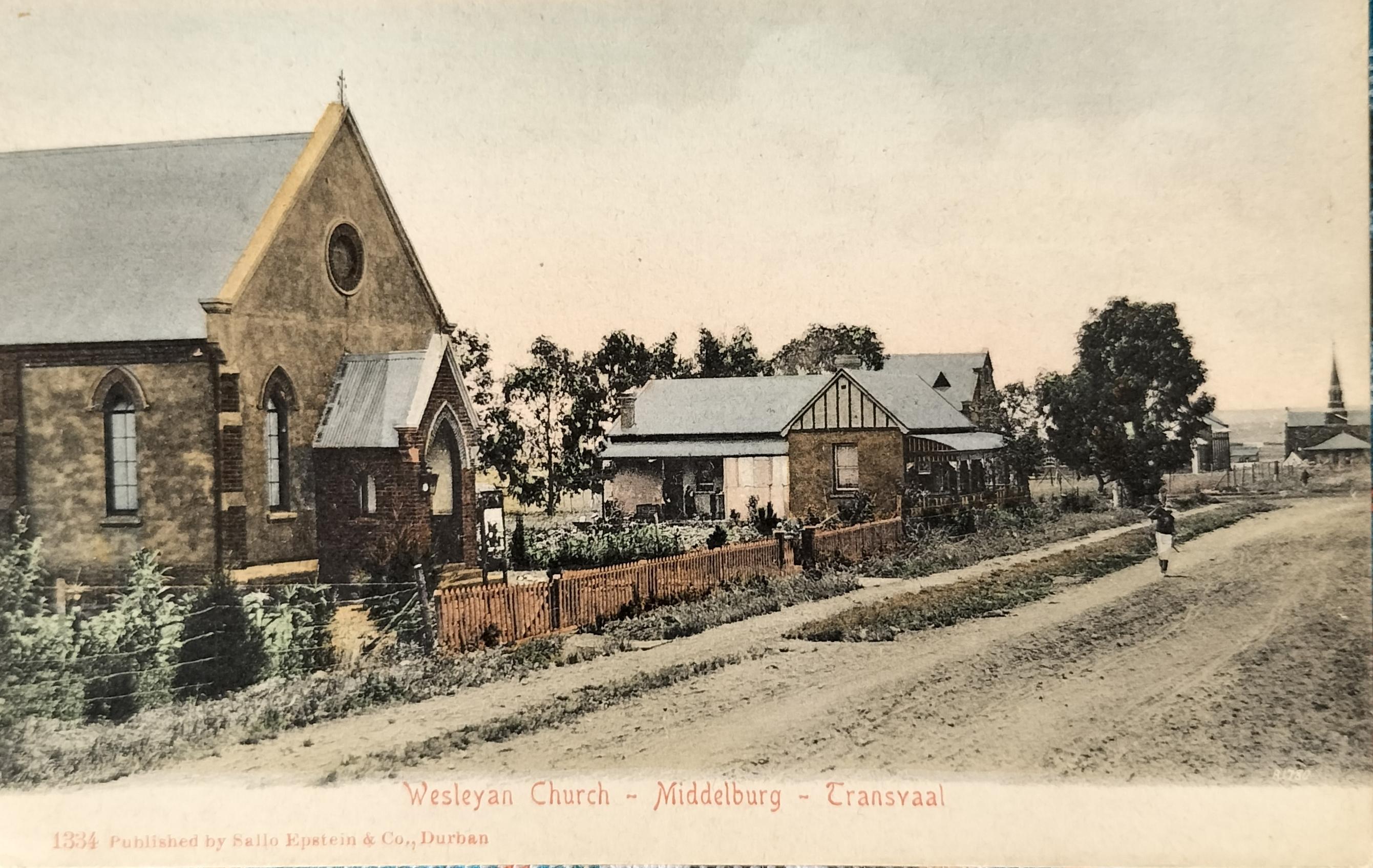
- Wesleyan Church (Methodist): Established in 1894. The church was based on Middel Street (later Voortrekker Street). Church services were initially conducted in the Ebenhaezer school, but by 1898 the congregation had built their church. A private English school was also established at the church.
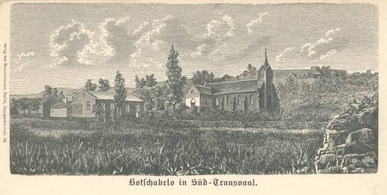
- Lutheran church (Botshabelo): Some fifteen kilometres from Middelburg, this church was built in 1868 already. The mission station was started by Alexander Merensky (father to Hans Merensky) who was attached to the Berlin Missionary Society.
- Lutheran Church: Stands in Laver Street. Used today as a wedding venue.
- St Joseph’s Catholic Church – Although the Roman Catholic Church had earlier activity in Middelburg, it is unknown when or where their first place of worshipping was built. It seems to have been a corrugated iron complex at first. Today, located on Jan van Riebeeck Street (Cowan Ntuli Street today), the cornerstone of the church was laid in 1945.
English Church in Middelburg (Anglican) which stood on the south-easterly corner of Mark and Voortrekker Streets (OR Tambo & Bhimy Damane today). The initial complex was built in 1887 and underwent alterations in 1902. A Church Hall in the same style was also built on the same stand which stood parallel with the church complex. Card published by Sallo Epstein (circa 1902). Hilligan Collection.
The same English Church as above (Anglican) which was built in 1887. This church stood on the south easterly corner of Mark and Voortrekker Streets. The card was published by an unknown publisher (circa 1906). Note the five British soldiers standing in front of the church.
The Wesleyan church, built in 1898, was based in Middel Street (renamed Voortrekker Street). Church services were initially conducted in the Ebenhaezer school. In the background, on the right, the Reformed (Hervormde) Church (on the corner of Middel and Coetzee Streets) can be seen.
Botchabelo – a very early post card produced from an etching. Botchabelo, a mission station a few kilometers outside Middelburg, was established in 1865. The church was built in 1868. In order to protect the small settlement a fort, called Fort Wilhelm, was also built.
5. Medical Care
The hospital history in Middelburg originated with the establishment of a hospital to provide care during the war against Sekhukkune in 1878. During the preparation for the Anglo-Boer War, a make-shift hospital was created in the Beer Hall with the bar counter serving as the operating table. The British later opted to deploy No 17 Stationary Hospital in the centre of town for wounded or ill soldiers, for the duration of the war. During the same time, the Middelburg Cottage Hospital was also established for civilian care.
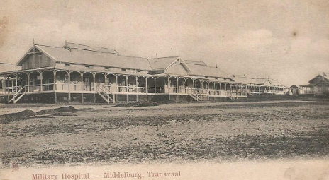
After the Boer War, a British Garrison was stationed in Middelburg equipped with a Military Hospital until the Garrison was withdrawn in the build-up to the First World War.
Following the Great Flu of 1918 the need for a permanent hospital was re-emphasised following which Middelburg Hospital, opened on 10 March 1921. This hospital expanded into the 1930s until the larger hospital, designed by Gerhard Moerdyk, was opened in 1939.
Military Hospital in Military Cantonments which was located in what is Clubville today. Card published by unknown publisher. Card extracted from internet – Middelburg Hospital History (Middelburg Info).
6. Schooling in Middelburg
The first school activity is recorded to have taken place in the 1870s. On 8 November 1876, van der Linden is appointed as head teacher with the school opening in December of the same year in the Hervormde Church in Market Street with nineteen pupils. This number grew to forty-four pupils at the end of 1877.
In 1879, a private school opened for English-speaking children with another opening a year later. None of these two schools survived after two years in existence.
As of 29 January 1883, the church complex of the Dutch Reformed Church on Church Street was used again for education purposes. On 16 May 1890 the school, with eighty students, was separated into a boy’s and girl’s school, only to be combined again under one roof in 1898.
In 1894, the Dutch Reformed Church built its first school – a Victorian-styled building (Ebenhaeser). The architect was JW Zernike & and the builder was R. Gerhardt. The cornerstone was laid on 31 January 1894. This same complex was also used by the Wesleyan Church for their services.
Formal schooling came to a standstill during the Anglo-Boer War period (1899 -1902).
After the war, Afrikaans parents were reluctant to send their children to the English “Free Schools,” resulting in the establishment of Christelike Nasionale Onderwys (CNO) schools in 1903.
From 1902, the Middelburg Free School was held in the Reformed Church building. The Free Schools obtained their school building in 1904.
The CNO, Middelburg Public and South (Free School), as well as Middelburg Secondary Schools, combined into one school in 1908.
On 10 April 1918, the High school separated themselves from the merged entity. Classes were held at the Ebenhaeser building until the High School building was completed in 1921. The English primary school was established shortly thereafter - August 1921.
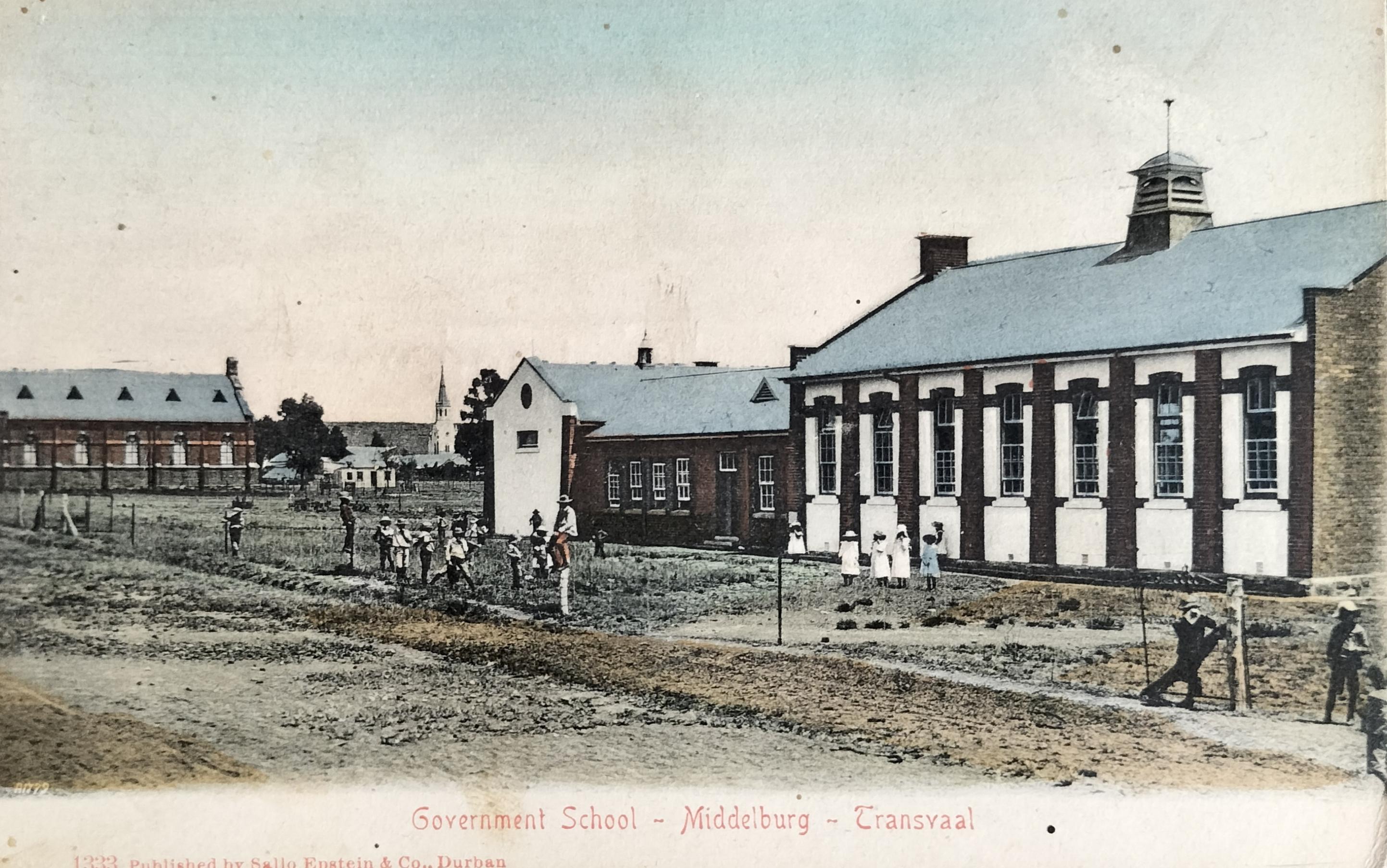
The Government School (Free School) was built in 1904. To the left of the school stands the Reformed (Gereformeerde) Church (corner of Voortrekker and Coetzee Street). During the Anglo-Boer War, the church complex was used as a school for children in the concentration camp. In the background the Dutch Reformed Church (Wit Kerk) can be seen. The image was captured from Voortrekker Street looking north west. Card published by Sallo Epstein (circa 1907). Hilligan Collection
The Middelburg Excelda school/orphanage which stood on the corner of Paul Kruger and Coetzee Street. The Architect was JW Zernike & and the builder R Gerhardt. The cornerstone was laid on 31 January 1894. The complex only functioned as an orphanage for 4 years after it was occupied in 1904. The complex was also used by the Wesleyan Church for their services. Card published by Sallo Epstein (circa 1904)
7. Structures of historical significance
The following structures in Middelburg are also of historical significance.
- Powder House – The first public building to be built was the Kruithuis (Arsenal). Middelburg was the hub of ammunition distribution in the old ZAR. Built by a local builder, Mattian Coetzee, it was completed as early as 6 April 1875
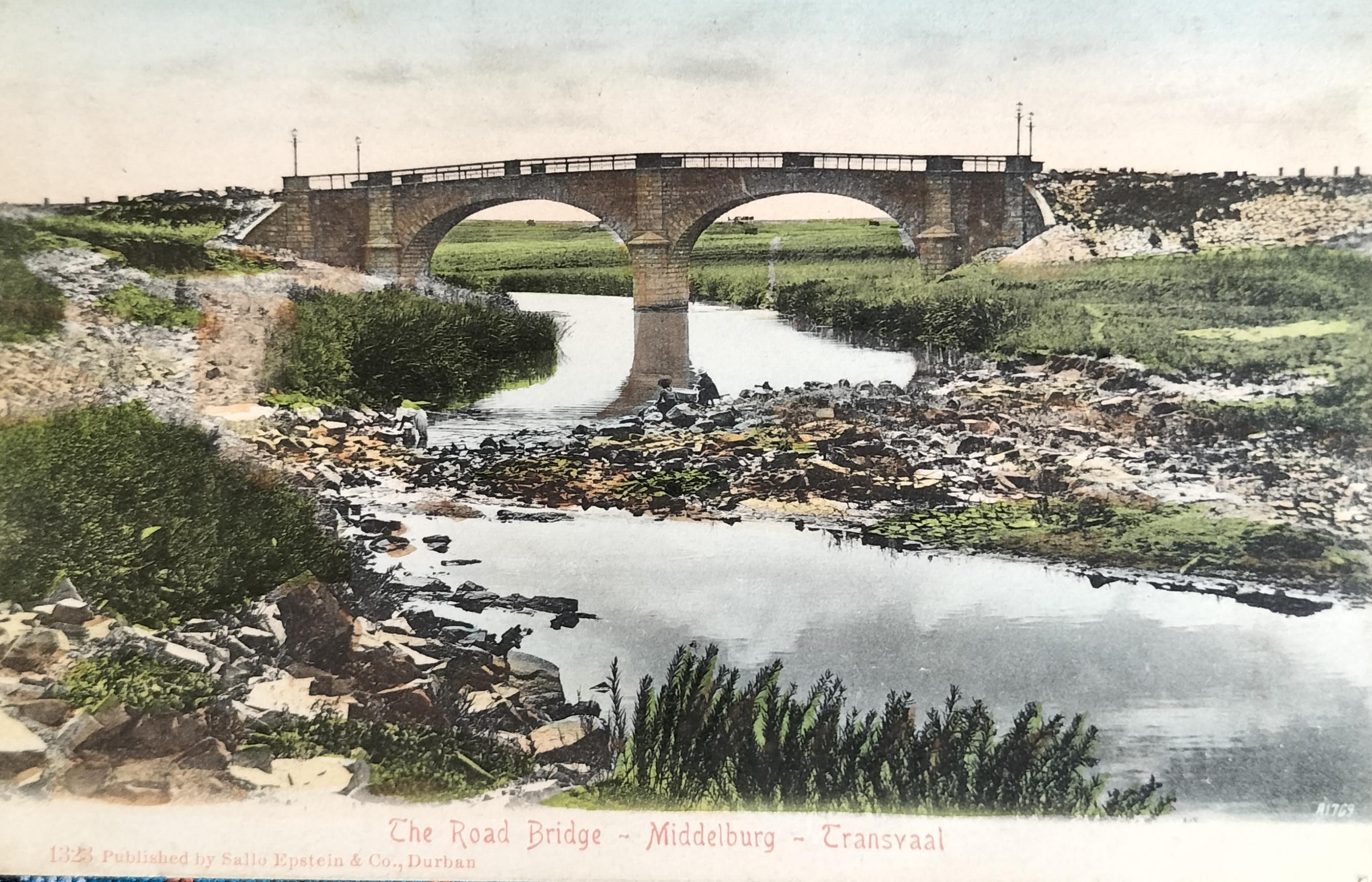
- Meijer Bridge - also Meyer Bridge - is one of the finest stone bridges built by the Zuid-Afrikaansche Republiek. The bridge is named in honour of Isaac Johannes Meijer, who represented Middleburg in the Second Volksraad, the Executive Council of which passed the Act for its construction in 1865. It was proclaimed a National Monument in 1968, and now a Heritage Resource in Mpumalanga since 1999. It was constructed in 1896 by an Italian contractor, Celso Giri. It is formed by two equidistant stone vaults, each spanning 18 meters. The site was surveyed in 1894, before Wierda’s recommendations that subsequent bridges be of stone construction. Wierda declared: ‘De brug lever teen schoon geheel op en is met haar gelijkkleurige zandsteen een der fraaiste boogbruggen in Zuid-Afrika.” (The bridge has a beautiful unity and is one of the most attractive in South Africa due to the homogeneous colouring of the stone). The steelwork balustrading on the superstructure bears the marks of ‘Mitcheson and Kolbrunner Durban.’
The Meijer Bridge over the Klein Olifants River, constructed by Italian contractor, Celso Giri, was completed in 1896. The bridge was named in honour of Isaac Johannes Meijer, who represented Middleburg in the Second Volksraad. Note the lamp poles on each corner of the bridge. These were probably manually lit at night as there was no electricity in town at the time the bridge was built. Card published by Sallo Epstein (circa 1905).
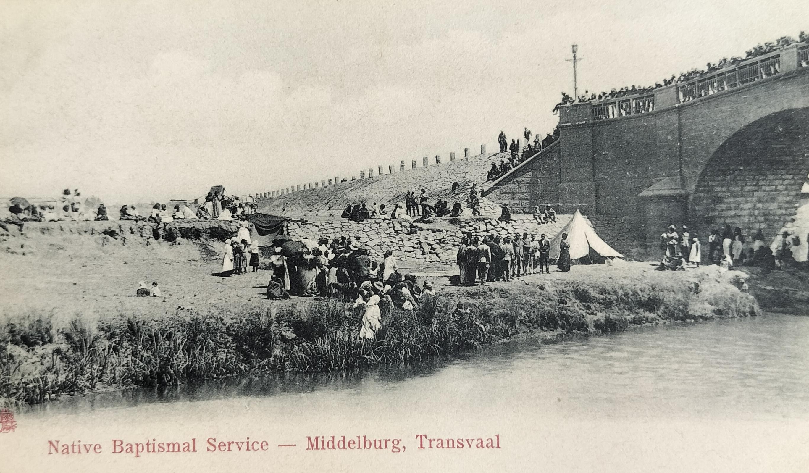
Zionist christening taking place in the Klein Olifants River next to the Meijer Bridge. The process entails dipping an individual underwater three times. These events turn out to be an all-day event or weekend outing. Card published by Raphael Tuck and Son (circa 1905).
- Courthouse and Prison - Middelburg’s first Courthouse, still in existence today, holds a surprising revelation according to a creative tour operator who alleges that the first Prison was not adjoining the Courthouse, it was under it! The tour operator continues by stating that three trap doors allowed prisoners to be lowered into a maze of adjoining crawl spaces and was not big enough for a man to stand or even sit comfortably. The tour then concludes that this aspect sheds an interesting light on the life of convicts and the treatment of fellow human beings in the town’s early history. This all turned out to be the figment of the tour operator’s creative imagination resulting the town’s history being harmfully skewed.
No early postcards of the Powder House or the First Courthouse have been identified to date.
8. Historical Snippets
Below are some historical snippets of interest around the development of the town of Middelburg:
- In the year 1874 the town only had seven houses;
- The Kruger Dam was built in 1897 by the ZAR;
- Water canals were built next to the main roads in town to provide water to stands in town. Water was provided via these canals until the early 1960s. The water was channelled from the Kruger Dam;
- The Alfred Robertson Dam, named after a previous Administrator of Transvaal, was only completed in 1918;
- The first known Bank to open in town was De Nasionale Bank der Zuid-Afrikaansche Republiek (1892), which later became The National Bank. The Bank of Africa also had a branch in town from at least 1900. Over the years, both these Banks merged into what eventually became FNB;
- The original Town hall, built in 1902, was based in Eksteen Street (the building no longer exists);
- Before the establishment of the railway station, the post between Pretoria and Middelburg was transported by spring wagon, pulled by six oxen;
- The first town council was selected in January 1903. During the elections, 305 of the 361 registered voters voted before 12h00 on the day (12 December 1903);
- The first elected mayor was HO Eksteen;
- In 1903, the town consisted of 3685 souls. It is not known whether this number includes the British Military based in town at the time. By 1952, this count increased to 9364 souls;
- In 1921 a power station and distribution system was put in place;
- The town council developed plantations on town lands to supply the town with wood;
- The town’s second courthouse (and Post Office) burnt down in 1907 in which all prisoner records were lost. It was subsequently rebuilt;
- On Rooth Square (named after the land surveyor), a memorial was erected in 1938 in memory of the Burghers of the Middelburg district who gave their lives for their country during the war;
- A Memorial Hall, currently located on the Technical High School grounds, was erected to remind people of Middelburg of the victims of the Anglo-Boer War;
- In the centre of the cemetery is also a British Garden of Remembrance for those soldiers who died in and around Middelburg;
- The first movie shown in town before 1909 was at the Coopers Bioscope. This same bioscope was later converted into an ice rink. The Mascot Theatre then showed its first film in 1912 (before the time of electricity);
- The town’s oldest surviving newspaper, the Middelburg Observer (first known as the Herald) came into existence in 1903. The owner and the Observer’s first editor, Oscar Henry Frewin, was widely considered to be the man who did the most for community newspapers in South Africa. Three generations of Frewins have since owned the paper before selling it to the Caxton Empire;
- An earlier employee of another publication, the Middelburg Courant (established late 1890s), was Arthur Griffiths (1871 – 1922) who returned to the country of his birth, Ireland, where he founded Sin Féin. He briefly served as the Irish president from January 1922 until his death later in August the same year;
- Building material for General Smuts’s house on the farm in Irene originated from the original British military installations in Middelburg.
Church Street in Middelburg (looking south) with Church Square on the left. Publisher of card unknown (circa 1907). Hilligan Collection
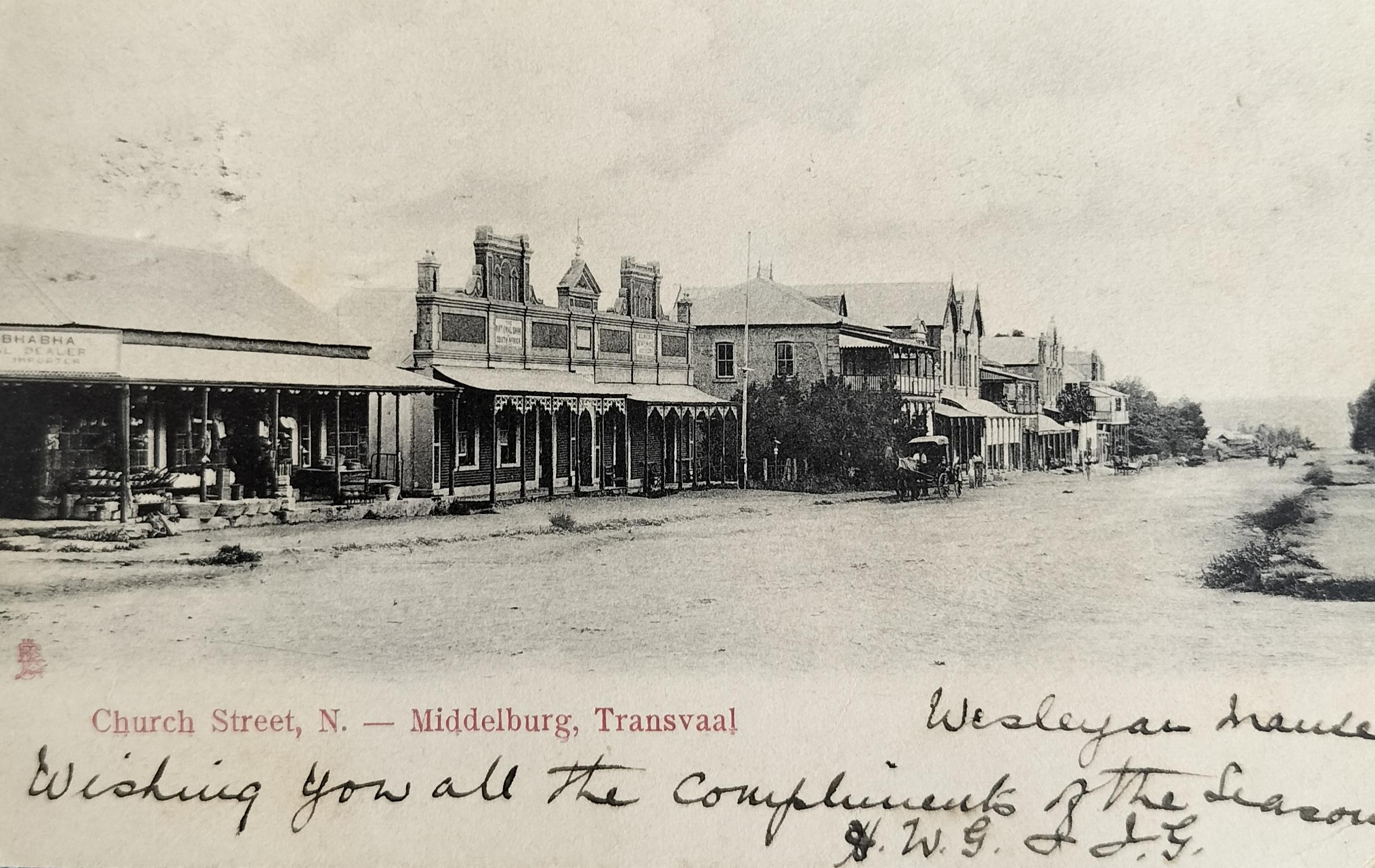
Church Street in Middelburg captured from the corner of Long and Church Streets (looking north). The first shop on the left is the general dealer, AE Bhabha. The next building (or part thereof) was The National Bank of South Africa (a predecessor to FNB). Where the horse-cart stands, was the Middelburg Club. Card published by Raphael Tuck and Sons (circa 1907).
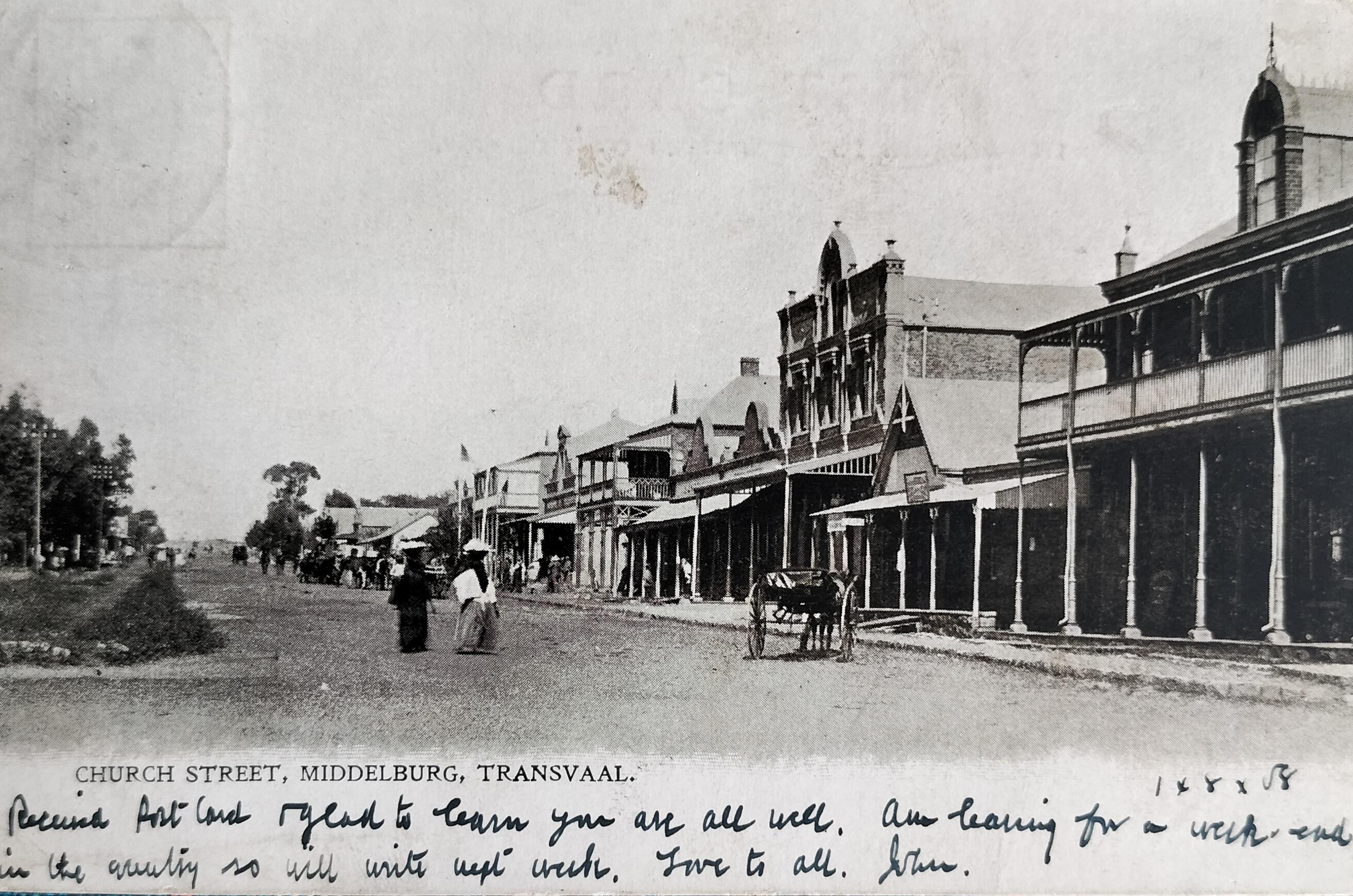
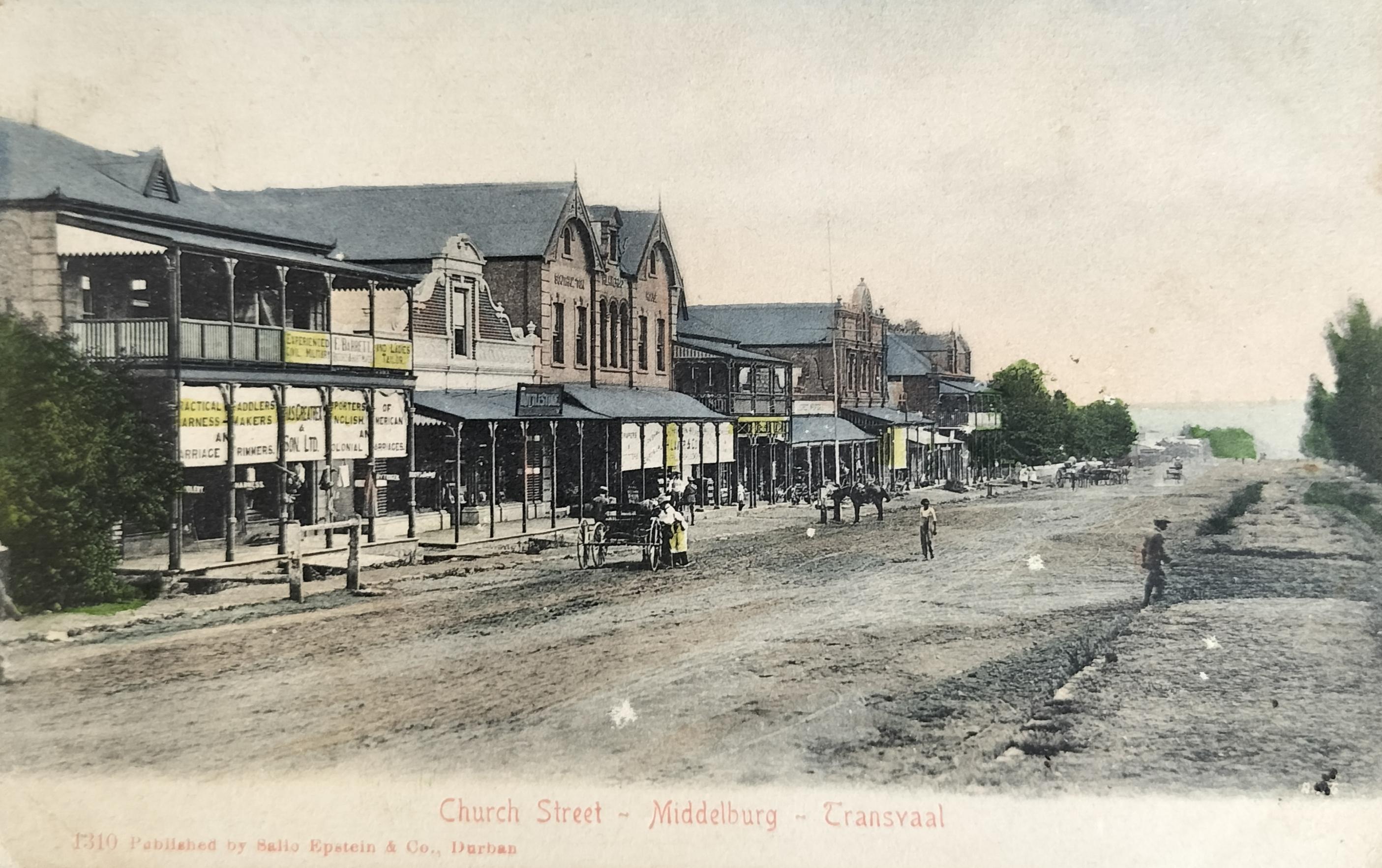
Church Street (looking north). The Middelburg Club stands behind the trees on the left. The first visible building is that of the local carriage maker, followed by a bottle store, followed by H. Laver Grocers. The person on the right is probably walking down Eksteen Street. Card published by Sallo Epstein (circa 1904).
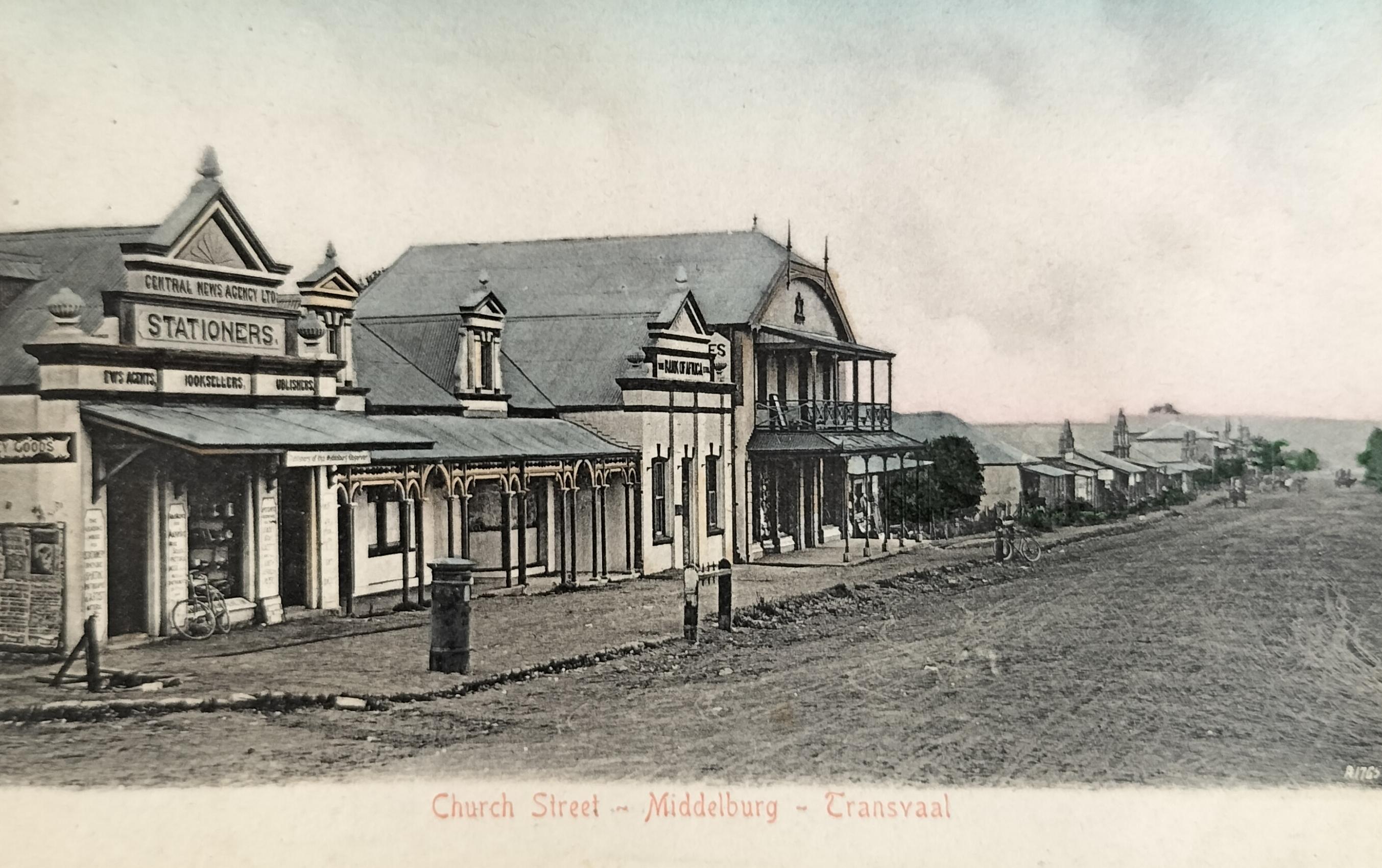
Church Street in Middelburg (looking north), showing the Central News Agency on the left, with the Bank of Africa next to it. Note the post box and hitchrack. Card published by Sallo Epstein (circa 1905).
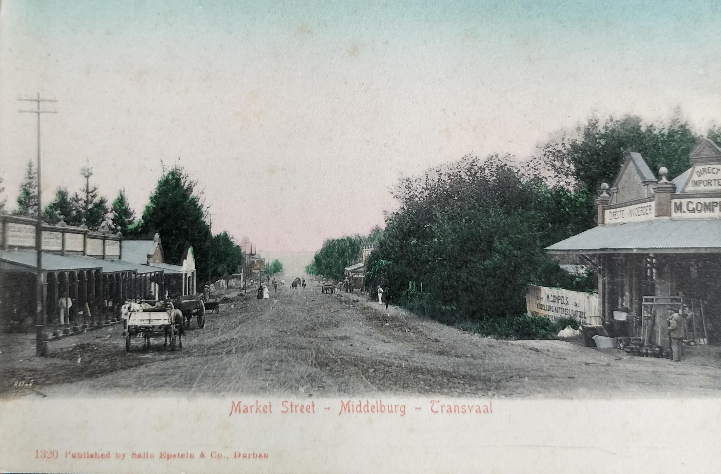
Market Street in Middelburg (looking south). On the right is the mattress manufacturer M. Compels. Note the telegraph poles on the left. In the distance, on the left, the roof of the Imperial Hotel can be seen. Card published by Sallo Epstein (1905). Hilligan Collection.
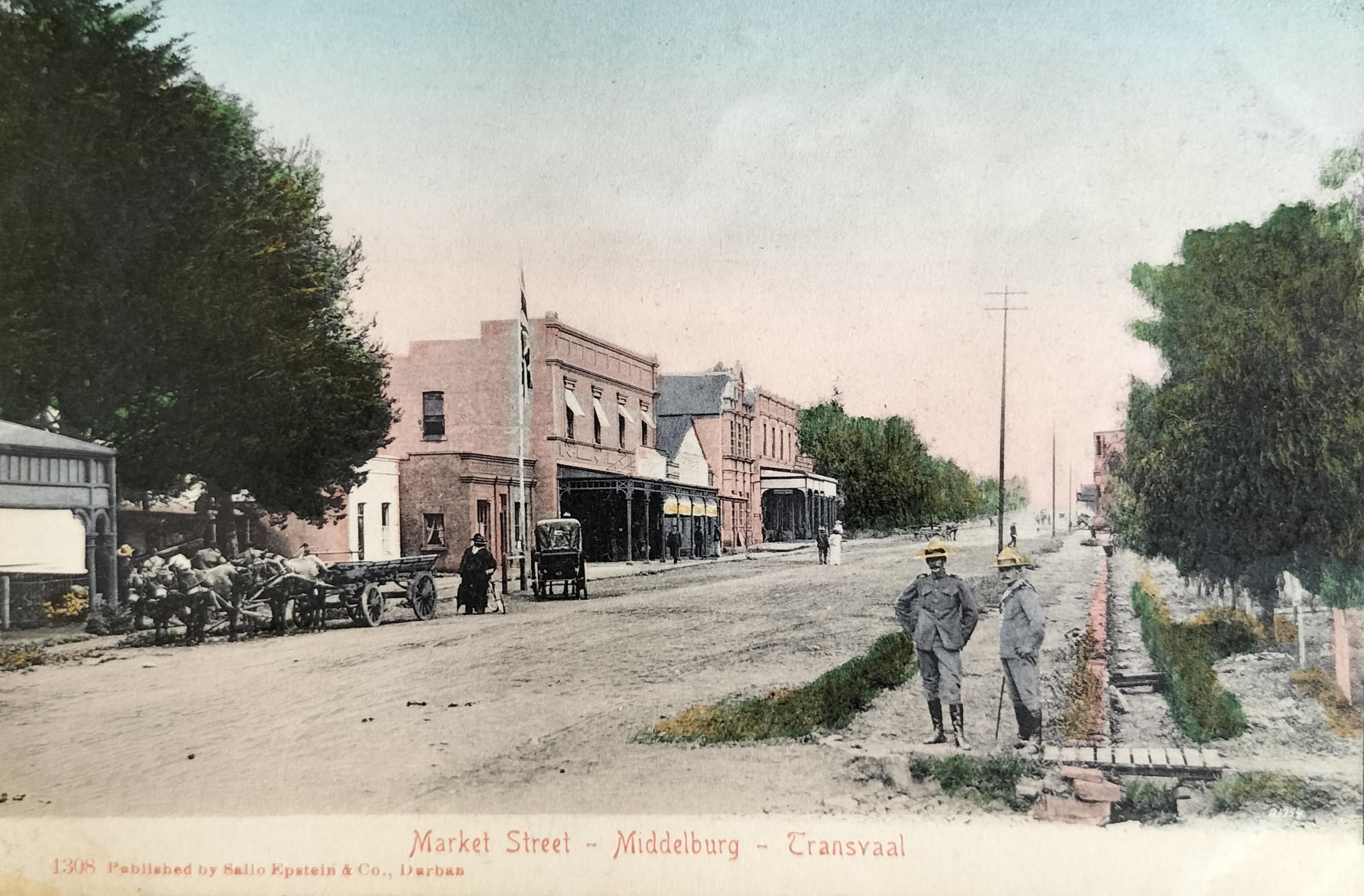
Market Street (looking south). The first double storey building on the left is that of the gents outfitters Crocker and Dicks. The building immediately to the right is that of Milner. Note the British soldiers as well as the water channel on the right. Card published by Sallo Epstein (circa 1905).
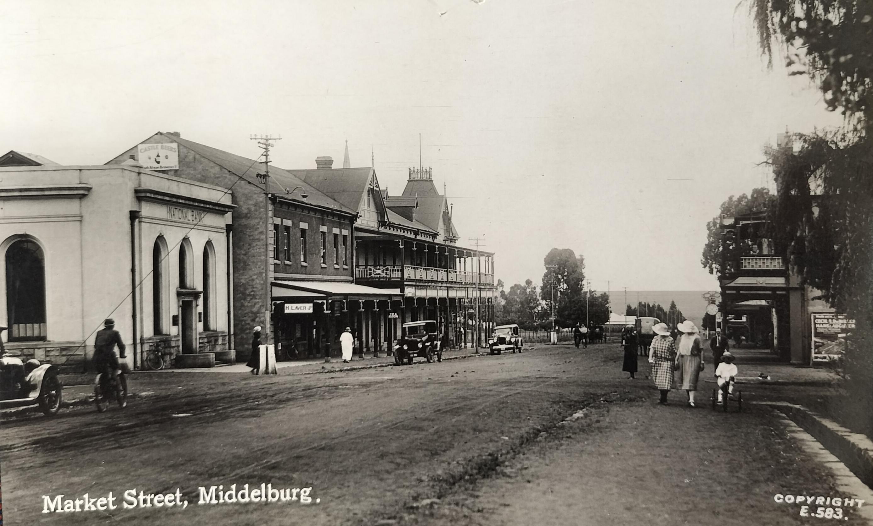
A more modern card - Market Street from the corner of Voortrekker Street looking north. The first building on the left is that of The National Bank (a predecessor of FNB). The third building on the left is the Imperial Hotel. The tower of the Wit Kerk can be seen behind the Imperial Hotel. Also, see the child on the tricycle as well as the water channel on the right. Card published by SAPSCO (circa 1920).
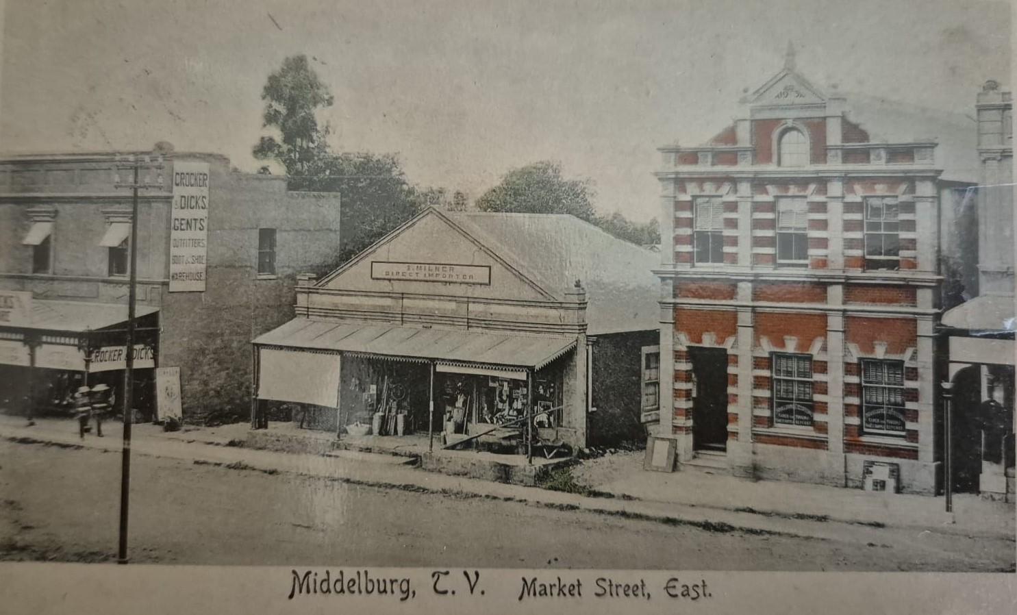
Market Street east showing the gents outfitters Crocker & Dicks on the left, with the shop Milner importers in the centre. Ownership of the unique red brick building on the right still needs to be determined. Publisher unknown (circa 1905).
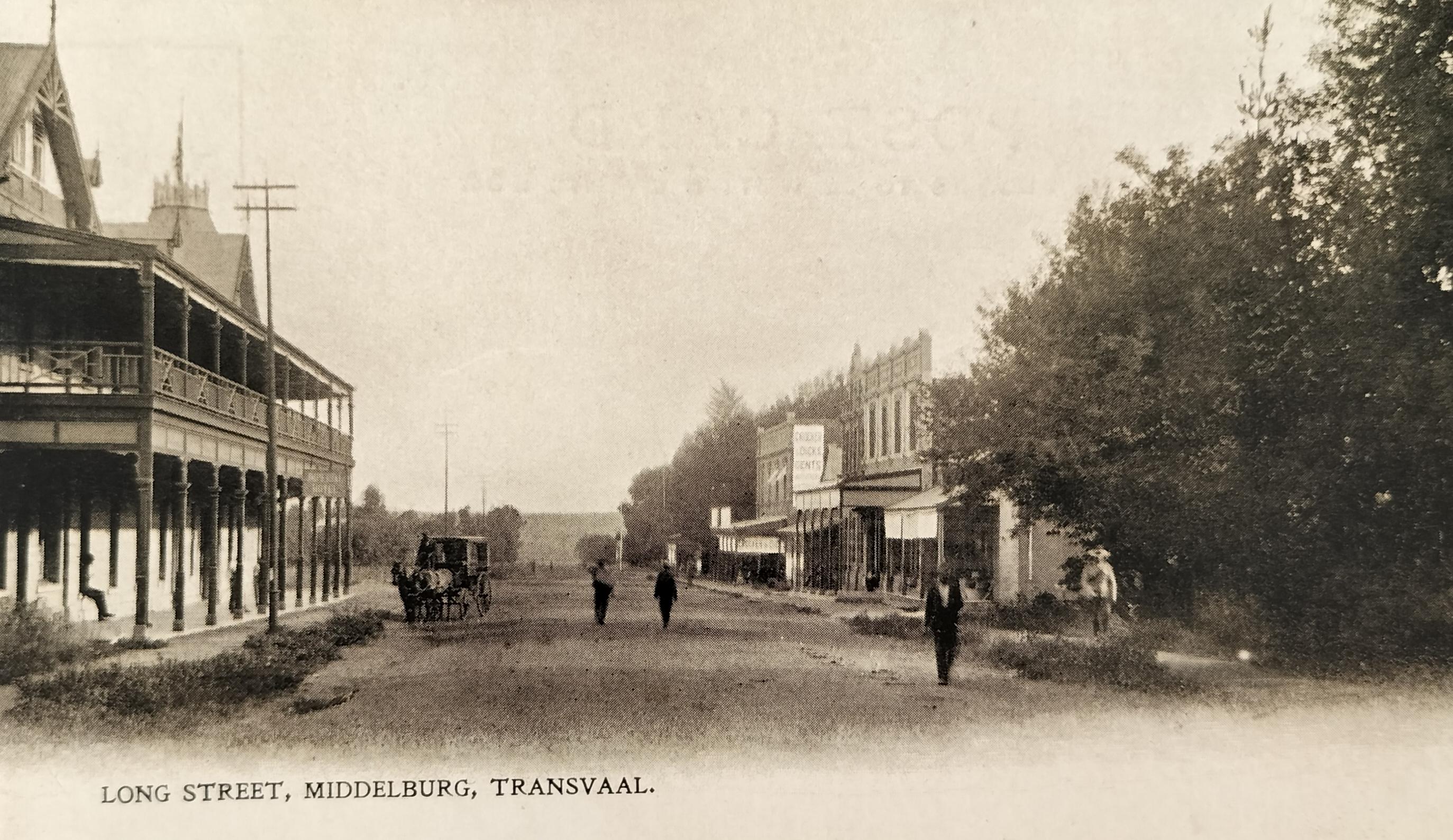
Although the card description suggests that this is a photograph of Long Street in Middelburg, it is more likely to be a photograph captured standing at the intersection of Long Street and Market Street looking down Market Street. The Imperial Hotel stands on the left. Card publisher unknown (circa 1908).
9. Photographers in town
Picture postcards are the resultant work of photographers who made an effort to record images of towns at the time. There was commercial value in doing so, especially during the period 1902 and 1909 when British soldiers would have bought the postcards to send them home, showing family members and loved ones the environment they found themselves in at the time.
Large publishing firms published most postcards. Sadly, in most instances, we will have no idea as to who the actual photographer was. Publishing firms either had their own photographers travelling around capturing images or they bought images from local photographers.
In the case of Middelburg, the two larger publishers of picture postcards were a Durban-based publisher, namely Sallo Epstein and United Kingdom-based Raphael Tuck and Son.
Middelburg did not attract many photographers early on in its existence. They only seem to have started settling in town from the 1900s onwards. Some of these may have contributed by capturing images for the larger publishing groups at a fee.
Differentiating who the photographers were that were based in the Cape and Transvaal towns of Middelburg is a challenge in that the photographers did not all indicate on their respective Carte-de-Visite or Cabinet Card format photographs in which town they were active. Some of the Transvaal Middelburg-based photographers (and publishers) that have been identified and confirmed to date include:
- Barraud John Kennedy – Also in partnerships (at various stages) with Farquhar and Pavey. Barraud in all probability was the first photographer to settle in Middelburg in that early 1880s photo formats produced by him are contained in the Hardijzer Photographic Research Collection (HPRC)
- Clegg HD
- Hollander George
- Farquhar
- Frenzel A
- Pavey Ernest (Royal Studio)
- Stobey and Wise (Church Street)
- Webster WT
- Whitaker’s Studio (Market Street)
- Williams L (The Studio)
- Young Roberts F
It is not known where any of these studios may have been based in town.
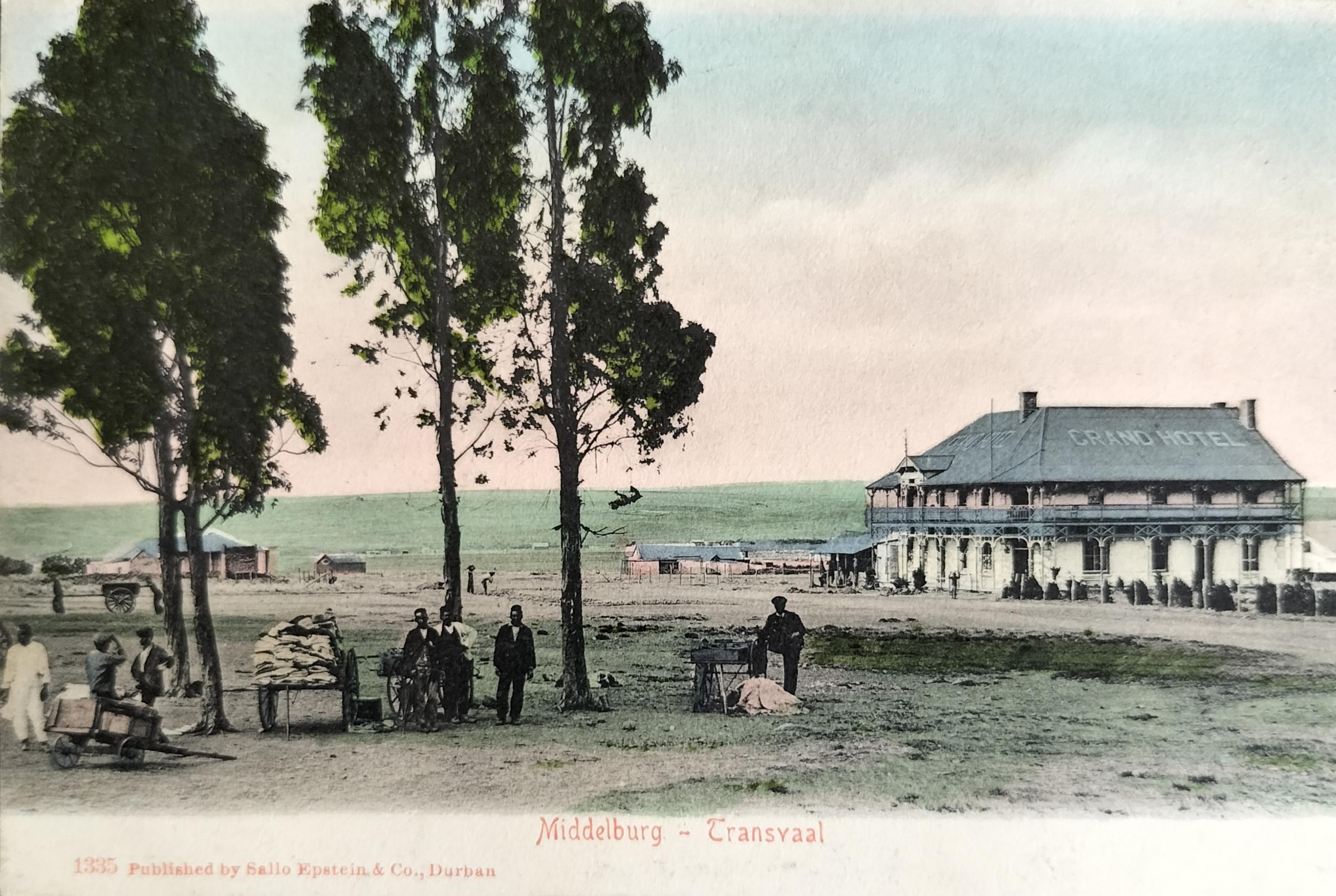
Grand Hotel in Middelburg. The road in front of the Hotel was the road from the Transvaal towards Lourenco Marques. The Hotel, located on the corner of Meyer and Jan van Riebeeck Streets just below the station, provided accommodation for rail travellers. The trees in the picture are on the site where the first Thos Begbies was established in Middelburg. Note the hawkers in the foreground. The man on the right seems to be standing at a milling machine of some sort. The three Indian men in the centre seem to be selling material. Card published by Sallo Epstein (circa 1905). Hilligan Collection
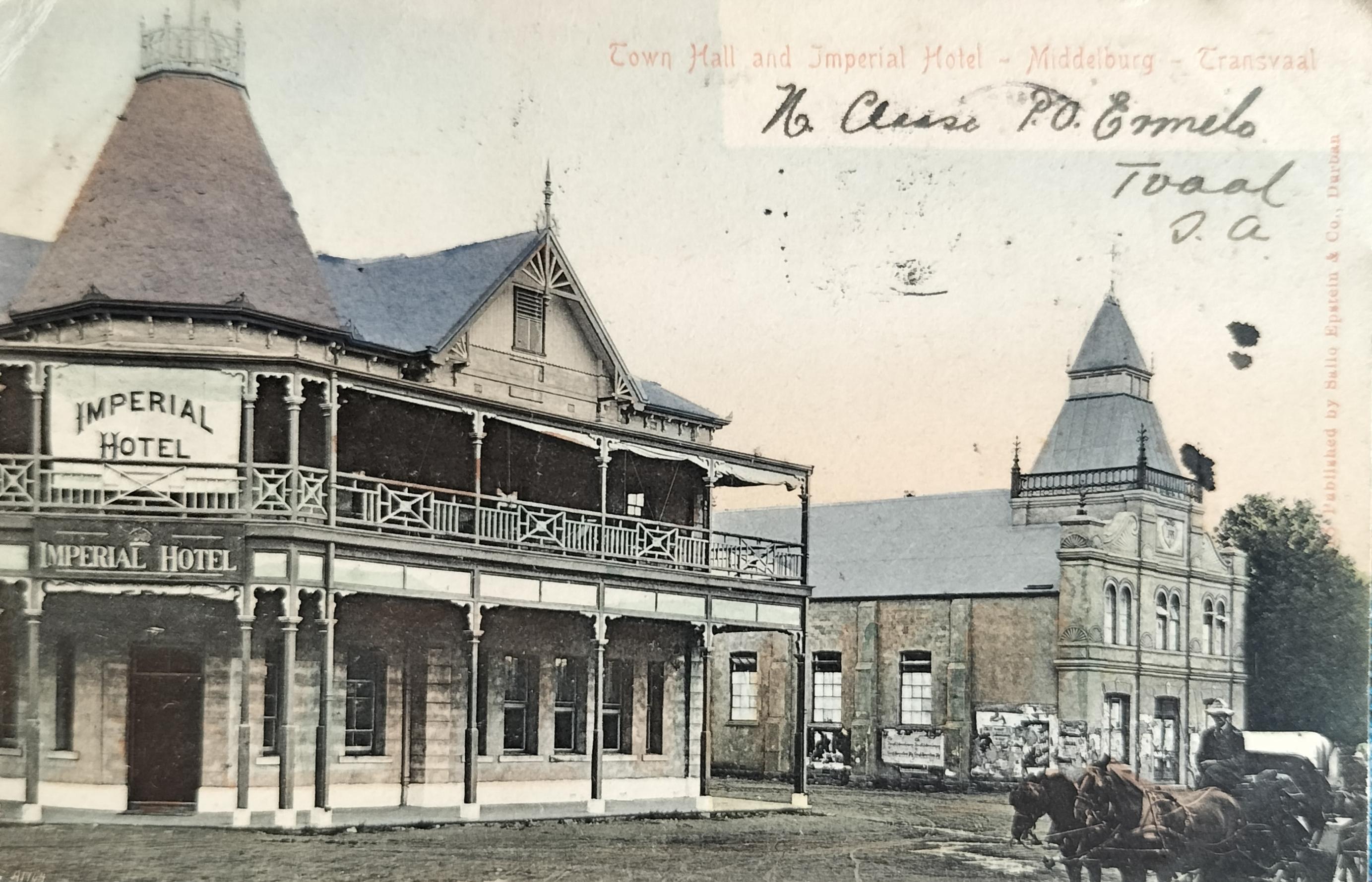
Imperial Hotel on the corner of Market and Eksteen Street in Middelburg. Next to the hotel stands the Town Hall (Eksteen Street) which was built in 1902. The Town Hall stood across from Rooth Square. Card published by Sallo Epstein (circa 1906).
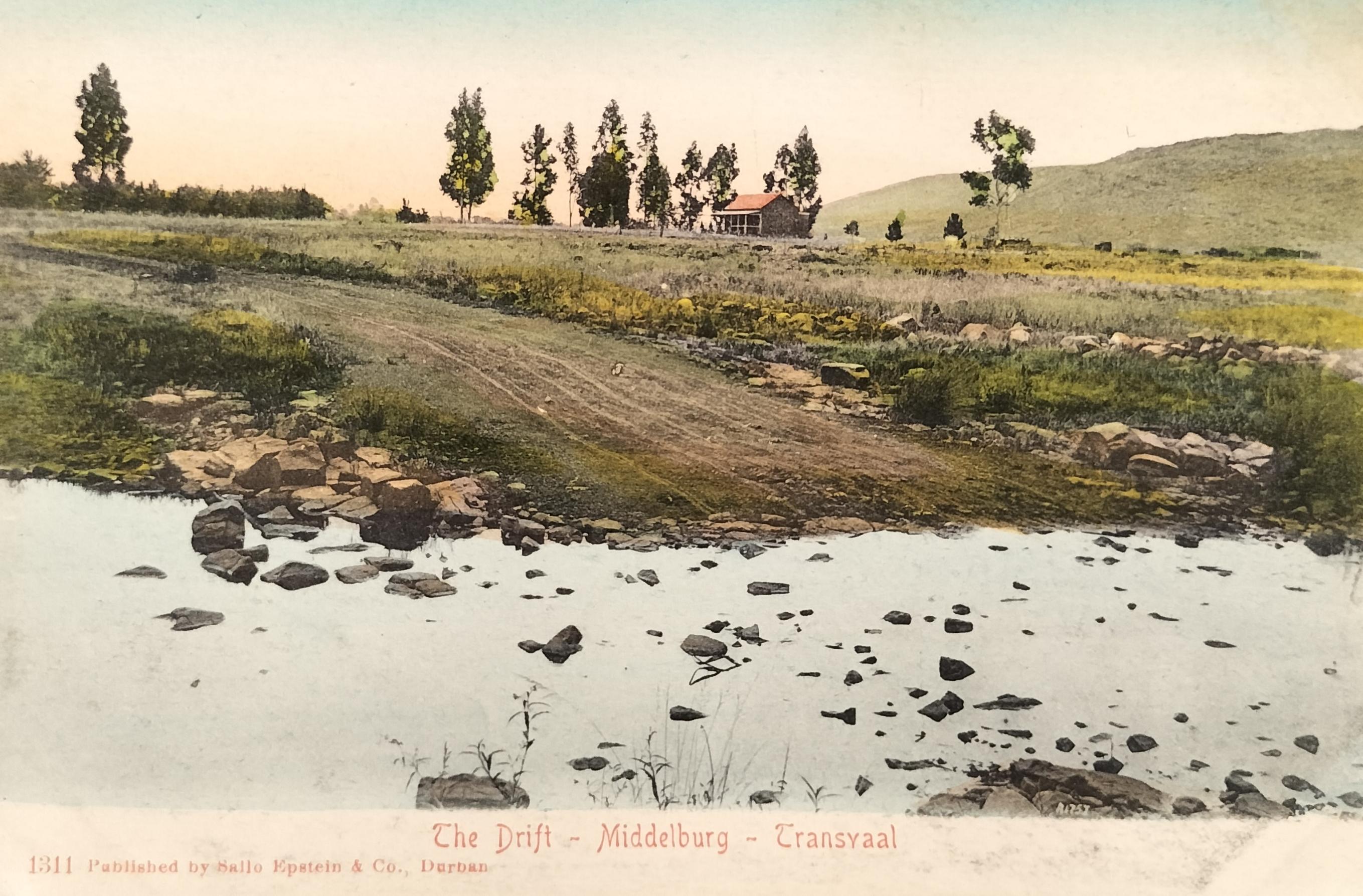
A drift near Middelburg thought to be on the Klein Olifants River towards the end of Church Street. Card published by Sallo Epstein (circa 1907).
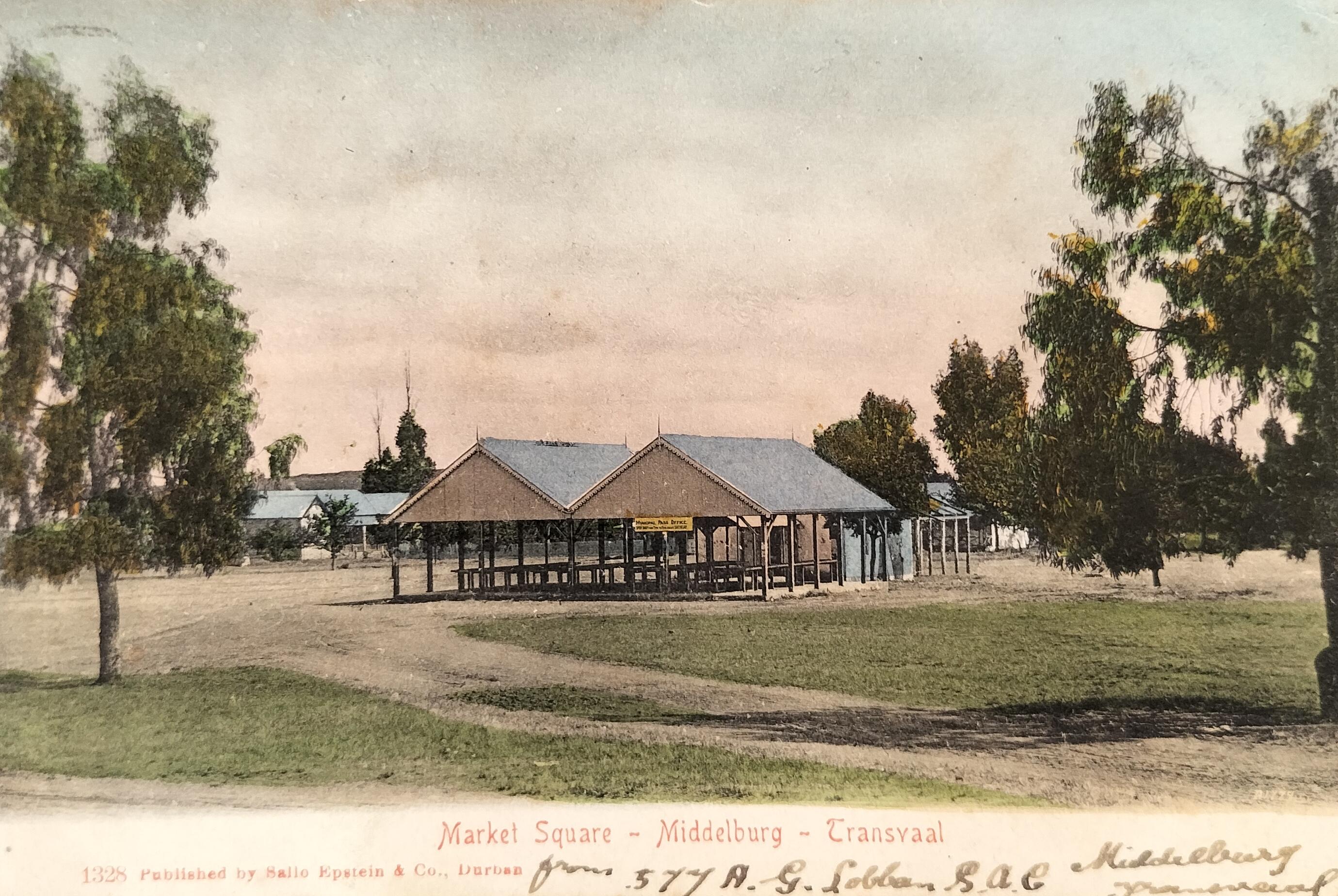
A Municipal structure on Market Square in Middelburg which stood in the middle of the market square on the northern side of the Wit Kerk. Card published by Sallo Epstein (circa 1907)
Closing
Not all buildings or structures in Middelburg were photographed for conversion onto commercial picture postcards, or it may just be that some cards had a lower print run due to a possible lack of interest in the subject matter contributing to their scarcity.
This article only focussed on the period between 1900 and 1920 and does not purport to be a complete factual representation of Middelburg’s early visual history.
Many more postcards must exist on Middelburg that could assist in expanding the visual history of this era. Missing in the visual representation above is for example a postcard on the Synagogue and early catholic church or a close-up of two of the three reformed churches.
Cards on towns of old Transvaal can be described as scarcer compared to the larger towns such as Johannesburg or Pretoria.
And the search continues.
The fourth article to appear on the Transvaal town series will be on Volksrust.
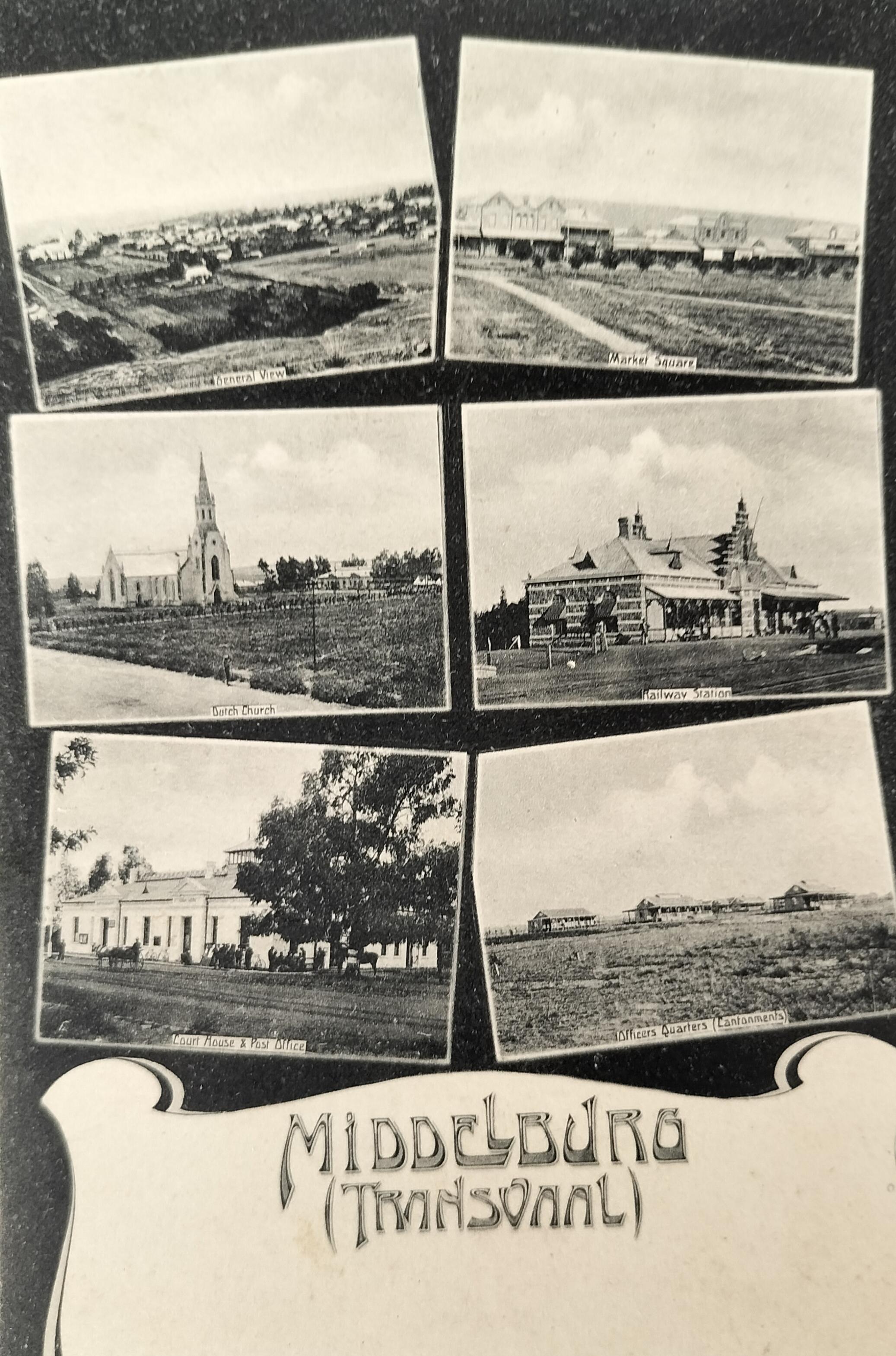
Multiple view card of Middelburg published by Braune & Levy (circa 1908)
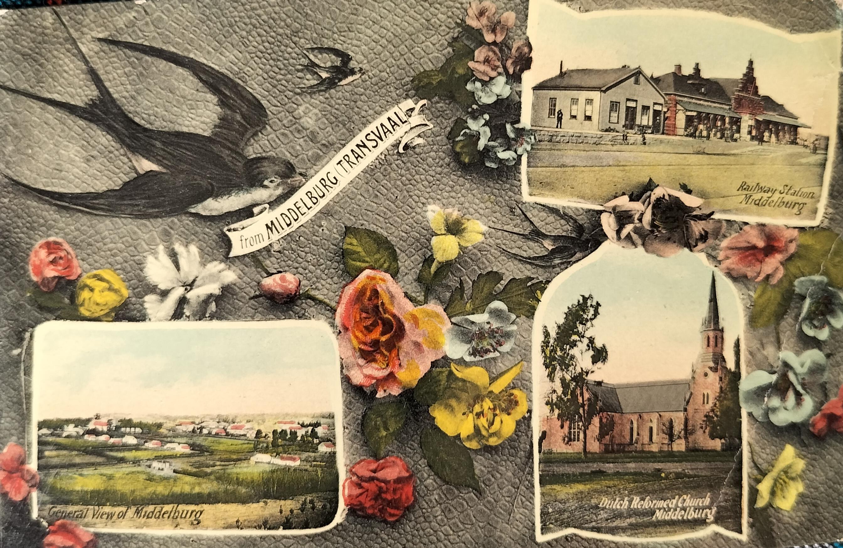
Main image: Multiple view card of Middelburg published by Middelburg-based George Hollander (circa 1905), showing the railway station and Wit Kerk on the right hand. Multiple view cards showing the swallow have also been published for other Transvaal towns at the time.
About the author: Carol is passionate about South African Photographica – anything and everything to do with the history of photography. He not only collects anything relating to photography, but also extensively conducts research in this field. He has published a variety of articles on this topic and assisted a publisher and fellow researchers in the field. Of particular interest to Carol are historical South African photographs. He is conducting research on South African based photographers from before 1910. Carol has one of the largest private photographic collections in South Africa.
Source
- Claassen, G.N. (Nd). Van Nazareth to Middelburg: Beeld van die geskiedenis van ‘n dorp. (Raad vir Geesteswetenskaplike Navorsing)
- de Jong, R.C., van der Waal, G.M. & Heydenrych, D.H. (1988). NZASM 100 – The buildings, Steam Engines and Structures of the Netherlands South African Railway Company. Chris van Rensburg. Johannesburg
- Frewin, O.H. (1975). Historical Middelburg – Transvaal. A series of old pictures reproduced from postcards and brochures. Frewin. Middelburg
- Grundlingh, F.A. (1952). Geskiedenis van Middelburg Transvaal – Saamgestel met die van Riebeeck-fees 1952. Frewin – Middelburg. Transvaal
- Hardijzer Photographic Research Collection
- Hilligan, R. Middelburg Postcard Collection
- Hoevers, J. (2009). Van Kerke en Dorpe. Sun Media. Stellenbosch
- La Grange, K. (2015). Ghostly adventures – Middelburg (www.mpumalanga.com/press-media)
- La Grange, K. (2015). Take a historical journey through Middelburg (www.mpumalanga.com/press-media)
- Ligthelm, T. (2018). Middelburg in en om die Anglo-Boereoorlog: ‘n Geannoteerde Kronologie
- Ligthelm, T. (2023). History of Middelburg - Powder House (middelburginfo.co.za)
- Ligthelm, T. (2023). History of Middelburg - British fortification on Kanonkop (middelburginfo.co.za)
- Ligthelm, T. (2023). History of Middelburg - Railway Station (middelburginfo.co.za)
- Ligthelm, T. (2023). History of Middelburg – Concentration Camp Memorial Hall (middelburginfo.co.za)
- Ligthelm, T. (2023). History of Middelburg – Meijer Bridge (middelburginfo.co.za)
- Ligthelm, T. (2023). History of Middelburg – Concentration Camps (middelburginfo.co.za)
- Ligthelm, T. (2024). Personal email communication between Ligthelm and Hardijzer dated 25 June 2024, 2 July 2024 & 4 July 2024
- Menache, P. & David, D.E. (2012). A Platteland Pilgrimage – 102 Country Churches of South Africa. Booktown Richmond Press
- Unknown (Extracted 15 March 2024). ZAR Road Bridge over the Klein Olifants River (Meijer Bridge) (artefacts.co.za/main/Buildings)
- Unknown (Extracted 15 March 2024). Middelburg – Mpumalanga (www.sahistory.org.za)
- Unknown (Extracted 15 March 2024). Middelburg Kinderhuis (www.gemeentegeskiedenis.co.za)
- Unknown (extracted 25 January 2024). Middelburg. Mpumalanga (Wikipedia.org)
- Unknown (extracted 25 January 2024). Middelburg. Mpumalanga (www.sahistory.org.za)
- Unknown (Extracted 6 January 2024). British Concentration Camps of the South African War 1900-1902 (www2.lib.uct.ac.za)
- Unknown (Extracted 15 March 2024). Middelburg Hospital History (middelburginfo.co.za)
- Unknown (Extracted 26 March 2024). History of St Johns Presbyterian Church – Middelburg (stjohnspresby.com/history)
- Unknown (extracted 17 June 2024). Botshabelo – Mission station near Middelburg (www.sahistory.org.za/place)
- van der Westhuizen, G. & van Westhuizen, E. (2013). Guide to the Anglo Boer War in the Eastern Transvaal – Revised edition. van der Westhuizen. Volksrust
Comments will load below. If for any reason none appear click here for some troubleshooting tips. If you would like to post a comment and need instructions click here.

