Disclaimer: Any views expressed by individuals and organisations are their own and do not in any way represent the views of The Heritage Portal. If you find any mistakes or historical inaccuracies, please contact the editor.
At age 6, while riding on the top deck of a bus to the German school I attended in Edith Cavell Street, Hillbrow, I noticed a white cylindrical post with black vane on the east side of Oxford Road just after crossing Glenhove Road. I asked my older sister and father what it could be but they had no idea. Although seeing it daily intrigued me then, I thought no more of it and, in time, forgot about it after our family had moved premises.
Seventy-seven years later, in 2014, I again noticed the same post and realised it was a survey or trigonometrical beacon. The reason for not having seen it since my wife and I had moved to Melrose Estate in 1997 is because the beacon had partly been obscured by a hedge. Now that the adjoining stands had been cleared, the beacon was easily visible. The stands had been cleared to make way for a substantial office development comprising two huge office blocks, now partly occupied by Coca-Cola head office.
Retired professional land surveyor Werner Kirchhoff shows how he was able to confirm that the beacon he saw along Oxford Road in Rosebank was the one he used to see from a trolleybus years ago. (Itumeleng English - The Star)
Werner Kirchhoff paints a beacon that he rediscovered along Oxford Road (The Star)
Oxford Glenhove Office Building (The Heritage Portal)
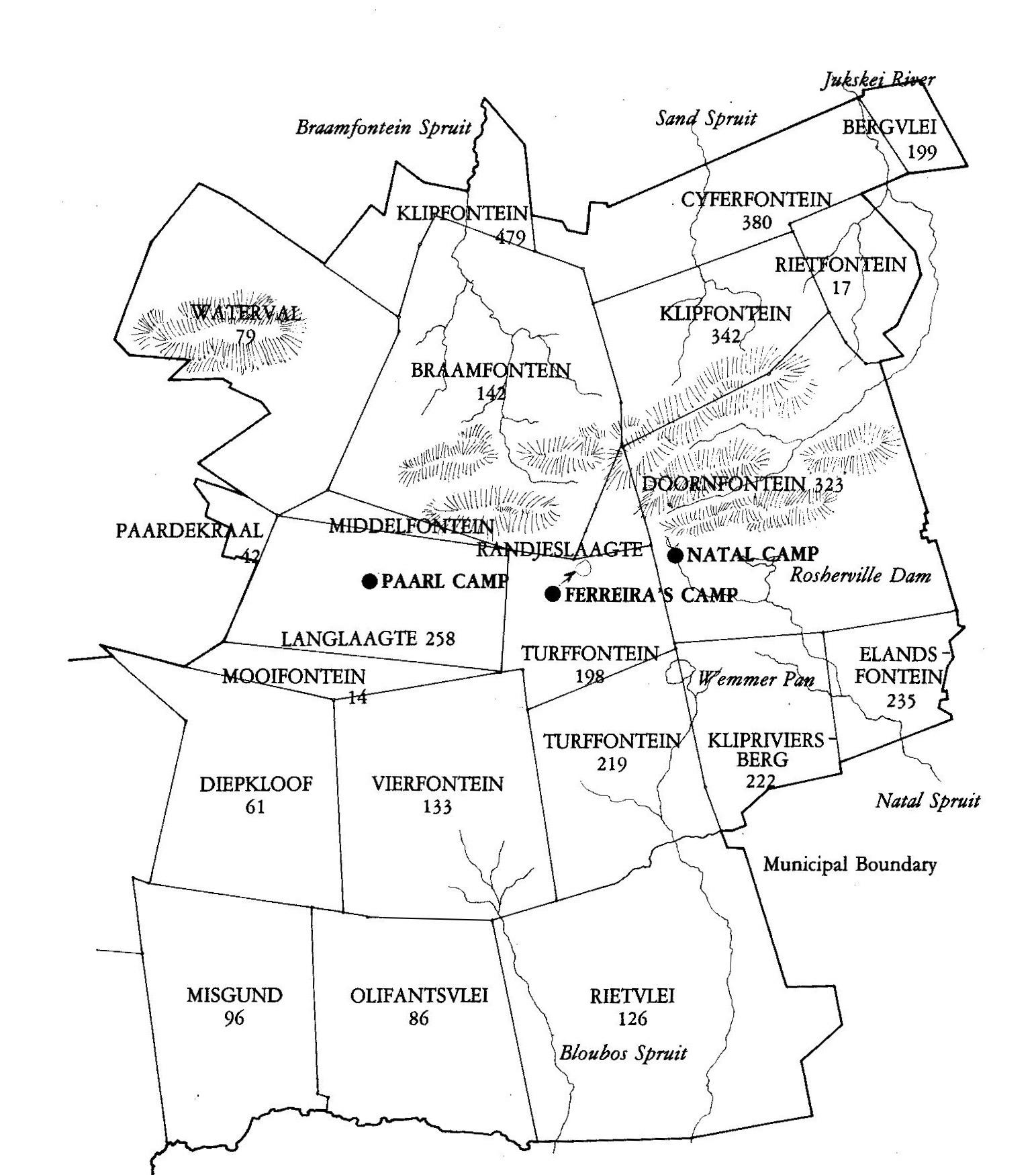
It’s of interest to note why two office blocks and not just one were necessary. The stands are separated by the boundary line between two original adjoining farms: Syferfontein in the north and Klipfontein in the south. Legally, one building may not straddle such farm boundary line. The basement of both buildings, however, was allowed to straddle across the old farm boundary.
Map showing original boundaries of, among others, farms Syferfontein, Klipfontein and Braamfontein (From Mining Camp to Metropolis)
The point demarcated by any survey control and coordinated trigonometric beacon is an important one as it is from this point that land surveyors can see and coordinate the surrounding farm portions, later survey townships and finally, mark off stands.
Situation of the beacon on the pavement of Oxford Road on the south-western corner of Stand 33, Melrose Estate. (Schrader, H. City Engineer, City Council of Johannesburg 1:5 000, 1951)
Enlarged diagram showing position of beacon (Kirchhoff Collection)
Because of its importance, I approached the new developers, Barrow Properties, and explained the significance of the beacon to them whereupon they agreed to preserve it. The beacon had been built on the pavement that now would have to be widened to make a slipway into the new buildings. I also pointed out that the beacon, being practically over the boundary between the two farms, should somehow be preserved.
It was therefore decided to erect a similar circular trig. beacon to replace the original some metres to the east of its original position and about three feet (0,9 m) from the original Syferfontein-Klipfontein boundary line. This was accomplished three years later, in 2017, when the new office development had been erected and Oxford Road had been widened. The original beacon was removed and I was told that it now lies in the courtyard of the new office development.
As I had requested, the replacement trig. beacon was erected in a planter very near the boundary line between the original farms Syferfontein and Klipfontein, which today separates Melrose Estate and Houghton Estate. (The Heritage Portal)
The restored beacon on Oxford Road now bears signs showing the three [original farm portions of] ‒ Syferfontein (now Melrose), Klipfontein (now Houghton) and farm Braamfontein [to the west]. From left: Land surveyor Werner Kirchhoff, architect Russell Katz and land surveyor Stephen Shires in front of the beacon. (The Star)
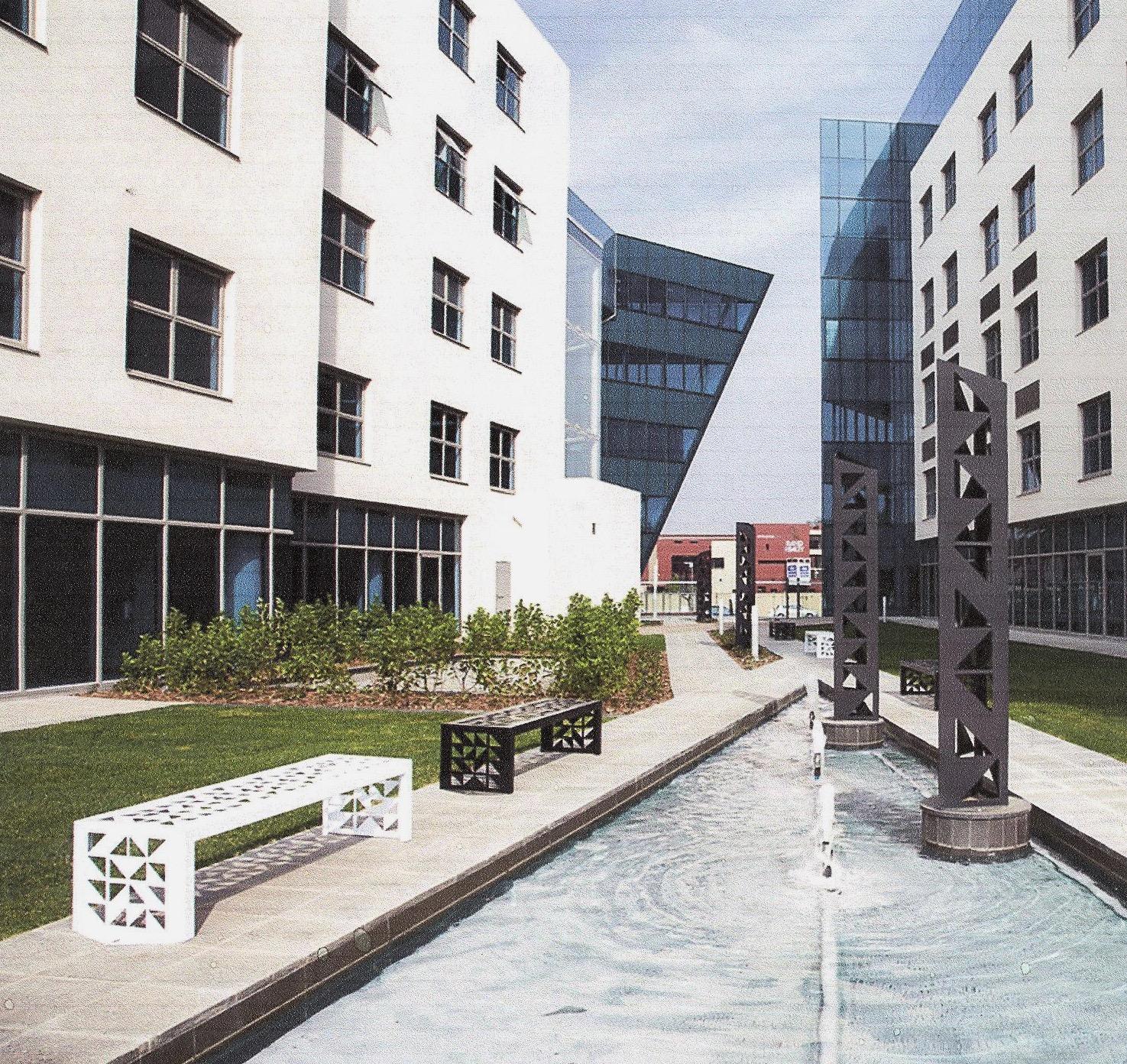
In addition to reinstating the beacon, the developers, happily, further demarcated the boundary between the two farms, which now separate the two suburbs. This was accomplished by erecting a series of distinctive square sculpted pillars in their courtyard along a long, stunning water feature and inside decorative flower beds.
Sculpted pillars alongside a water feature in the courtyard (Kirchoff Collection)
Finally, in 2017 Land Surveyor Stephen Shires wrote that he had “replaced the actual position of the [original] beacon as shown on the General Plan as a 20 mm iron peg in the new tarmac”.
History of the trig. beacon
The beacon has an interesting provenance. Land Surveyor Edward Harker Vincent Melvill was commissioned in 1890 by the Surveyor-General of the South African Republic, G.R. von Wielligh, to survey the Central Witwatersrand Goldfields, comprising 18 farms around Johannesburg. Melvill accomplished this task admirably, with an error of 1 part in 213 000, which is considered “a remarkable achievement”. It was known as The Witwatersrand Goldfields System of Triangulation.
The method he used, however, ignored the curvature of the earth, which was quite acceptable as his survey was over a limited area of 165 square miles (420 sq km). As Melvill’s local survey had become so entrenched, in 1919 Dr W.C. van der Sterr, the Union’s first Director of Trigonometrical Survey, extended Melvill’s survey northwards for about nine miles (14 km). Known as the “Northern Extension”, the beacon was descried as “on the side-walk of Oxford Road, about 100 m south of Glenhove Road”.
As land surveys have to cover the whole country, the curvature of the earth must be taken into consideration. During the 1920s Van der Sterr, therefore, replaced Melville’s Goldfields’ survey with a new system covering the whole country – the Gauss Conform System Lo[ngitude] 29°. With the Goldfields’ survey having become obsolete, the Oxford Road trig. beacon was incorporated into the new Lo 29° survey. In January 1930, it was used as a benchmark (altitude measurement) when framing (setting out) the “General Plan of the Township of Melrose Estate”. On this plan the beacon is designated as Beacon 302-1.
The south-western segment of the General Plan of Melrose Estate shows the Oxford Road Trig. Beacon as Beacon 302-1 (Kirchhoff Collection)
The Beacon conformed to the design used by Van der Sterr: a 1,2 m high concrete cylinder painted white with a removable vane signal painted black.
Close proximity to a former 1853 stone cairn
In addition to Beacon 302-1 lying very near to the boundary line between two farms, Syferfontein and Klipfontein, it is also near the corner point of three original farms, which meet in today’s island in Oxford Road. Originally the corner point of the farms was demarcated by a pile of stones and rocks ‒ a stone cairn three foot (1,1 metre) high ‒ that demarcated the boundary of three original Overvaal (Transvaal) farms: Braamfontein, which lay to the west of Oxford Road, Zijverfontein (Syferfontein) to the north-east and Klipfontein towards the south-east. Note that it was the farm Braamfontein, not today’s suburb of Braamfontein. Over the years, these farms have been subdivided, first into farm portions, then into townships and, when incorporated into the municipal system, they are known as suburbs. Today the beacon would mark the point of intersection of the suburbs Parkwood, in what was formerly a portion of the farm Braamfontein; Melrose Estate, in what was a portion of Syferfontein and Houghton Estate, a portion of former Klipfontein. Specifically, it is near the north-eastern part of Parkwood, the south-western extremity of Melrose Estate and the north-western extremity of Houghton Estate.
Sketch of original stone cairn demarcating farm corner beacon and triangulation beacon replacing it (Kirchhoff Collection)
The Dutch and Afrikaans words Braamfontein mean bramble fountain, Syferfontein, oozing fountain and Klipfontein, stony fountain.
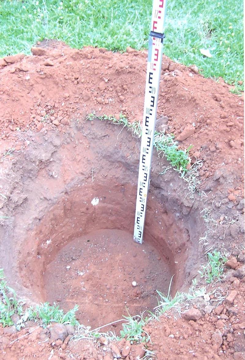
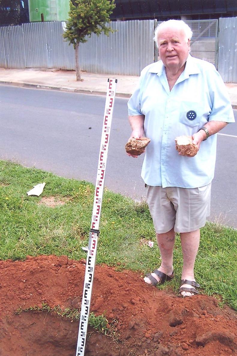
To prove that the original stone cairn existed in the middle of Oxford Road, one Sunday morning at 06h00 I, together with my gardener, dug a hole in the middle of the island in Oxford Road to try to locate the original stones that formed the cairn. The spot had been marked in white on the island to establish the boundary where the sculpted pillars should be erected. I excavated the spot and was pleasantly surprised to unearth six quartzite stones that formed the original cairn and two bitumen-coated tarred road stones. The six stones are some of the earliest memorabilia we have of Johannesburg.
The hole I had dug in the island of Oxford Road to prove that a stone cairn had stood there to demarcate the south-western corner point of Syferfontein and the north-western corner point of Klipfontein, both on the eastern boundary of Braamfontein. For road levelling purposes, Oxford Road had been filled over with sand at this point, hence the depth of the hole. (Kirchoff Collection)
Photo of me in front of the hole at the position of the original stone cairn. I’m holding the original stone cairn stones (Kirchoff Collection)
Six of the original stones that formed the original stone cairn and two later ones signifying the point of intersection of the three original farms Braamfontein, Syferfontein and Klipfontein. (Kirchhoff collection)
The original cairn farm beacon, now on Oxford Road centre line, was located and built by the ex-Natal Voortrekkers in the early 1850's. The few stones I found are from the original beacon. The beacon defined/marked the North West corner of Klipfontein Farm (now Houghton Estate) and the adjoining South West Corner of Syferfontein Farm (now Melrose Estate).
The location of the boundary was chosen by the newly settled Voortrekkers as it was on the small local ridge dividing rain flow west to the Braamfontein Spruit, east to the Jukskei River, north to Melrose and Henderson Park and south to the Saxonwold valley.
The Trig. Beacon in Oxford Road
Oxford Road was originally a track leading to Henry Brown Marshall’s portion of the farm Syferfontein. Transferred in 1899, he called his portion of the farm Melrose, which township was established in 1902. Part of the road was, in 1907, named Isobel Avenue, Melrose. Other parts bore the names Higham Street (1908), Houghton Avenue (1908) and Rosebank Road. This latter road and Higham Street were renamed Oxford Road in 1935.
On the Witwatersrand the pioneer farmers used a rise or ridge above their farms as one of their boundaries to ensure the water flowing from the ridge remained on their own farm. It was said that Marshall maintained the original firebreak between his farm and the next property. This, apparently, became a horse and riding path, then a wagon track, then, much later, a main road ‒ Oxford Road ‒ and recently a major section of the Gautrain tunnel and Rosebank Gautrain Station.
Blue Plaque
I also contacted Mrs Flo Bird of the Johannesburg Heritage Foundation to install a Blue Plaque heralding the replacement of Beacon 302-1. My original suggestion for a Blue Plaque was as follows:
Trigonometric - Farm Boundary - Beacon
This high point was... selected for a Goldfields Co-ordinated Beacon (original “GPS”). Thanks to Barrow Construction's preservation principle and Land Surveyor Werner Kirchhoff’s historical investigations, the new beacon has been built [very near to] the original farm boundary line between a portion of Klipfontein, now Houghton [Estate] and a portion of Syferfontein, now Melrose Estate. This line also required the separation of this new spectacular building designed by LYT Architects, whose architectural reverse slope motif has been retained in the beacon signal sighting vanes. (81 words)
As Mrs Bird told me that the wording on the Blue Plaque should be about 60 words, I abridged the wording as follows:
Triangulation and Farm Beacon
This strikingly rebuilt beacon replaced . . . a 1900’s survey control triangulation round white beacon common to S.A. The centre island of Oxford Road originated from a water divide farm boundary, fire break, horse and wagon track, to highway and Gautrain tunnel. The signal vanes retain the original farm names. (48 words)
The following photo shows the present Blue Plaque:
Oxford Road Trig Beacon (The Heritage Portal)
Regrettably, the present Blue Plaque has the following shortcomings:
- The passer-by will remain perplexed upon reading the three names on the vanes of the replacement beacon as he will not know the meaning of the words Syferfontein, etc.
- The passer-by will not realise the reason for the row of elegantly sculpted pillars behind the beacon: that they actually lie along, so defining, the boundary separating Syferfontein and Klipfontein.
- The passer-by should be made aware that the office block has been cut in half.
- Finally, the fascinating history of the beacon should be mentioned.
The following wording, therefore, is suggested for a new Blue Plaque:
Oxford Road Trig. Beacon 302-1
This strikingly new beacon was donated and built by Barrow Construction as suggested by Werner Kirchhoff, Land Surveyor. The original was built in 1919 for the continent wide triangulation system based on global co-ordination of X axis for equator and Y axis for longitude. This new beacon, fountains and sculpted pillars mark the exact boundary between Melrose (Syferfontein) to the North, Houghton (Klipfontein) to the South and Braamfontein (West of Oxford Road).
Werner Kirchhoff received his B. Sc. Engineering Degree from the university of Witwatersrand, in 1956. He is a member of the Institute of Professional Land Surveyors of the Transvaal. His professional experience has been extremely varied and most satisfying in being able to contribute to finding solutions to unusual problems. Early post - graduate surveys comprised establishing whole degree Lines of Longitude and Latitude in the Zambian (then Rhodesian) bush from basic astronomical field observations by precision navigation from stars. This led to an involvement of satellite tracking. He became associated with the Smithsonian Astrophysical Observatory in 1958 as an honorary observer for the International Geophysical Year and in 1959 he was asked to join the observatory staff and to be involved with satellite tracking and later managing the Smithsonian Institution’s precision satellite photographic observation station at Olifantsfontien. Certain observational innovations took him to the United States to the Smithsonian Astrophysical Observatory headquarters in Cambridge, Massachusetts, as technical advisor for South – west Observatory and project manager to establish a world – wide system of laser ranging instruments, being large theodolite total stations with “shaft encoders” and “stepping motors” to preposition the laser pulses to intercept satellites with cubic retro reflectors, observing return delays for distances accurate to a fraction of a meter over thousands of kilometres.
Returning to South Africa in 1970’s, a need was seen to serve the construction industry with laser instruments for greater speed and accuracy, especially in vertical control of high-rise structures, deep excavation, as well as providing high accuracy planimetric and level control using conventional, first order instruments and methods. He was appointed Consultant Land Surveyor on numerous large projects, among others on the three ultra-modern structures designed by the internationally famous architect Mr. Helmet Jahn for Anglo- American Properties, i.e., the diamond faceted 11 Diagonal Street, the horseshoe shaped 22 Girton Road and the spiral tower at 362 West Street, Durban. Other important appointments were to the South African Reserve Bank’s 35 storey headquarters in Pretoria, the tallest landmark building in Pretoria with its total glass and polished granite faced, the new Standard Bank Headquarters in Johannesburg, the Old Mutual steel structure, First National Bank’s Bank City, large ongoing hotel developments like Sun City etc.
The above varied experience allowed him to present numerous lectures and papers, e. g. “The use of Satellites for Surveying” to the “Scale of the universe”.
Comments will load below. If for any reason none appear click here for some troubleshooting tips. If you would like to post a comment and need instructions click here.

