Disclaimer: Any views expressed by individuals and organisations are their own and do not in any way represent the views of The Heritage Portal. If you find any mistakes or historical inaccuracies, please contact the editor.
The topography of Johannesburg is distinctive with the rocky mountainous ridges and the line of koppies that runs from east to west. These are the quartzite ridges of the famous Witwatersrand. The geology is unique. Viljoen and Reimold (An Introduction to South Africa’s Geology and Mining Heritage) make the point that this is one of the few localities where the evolution of the granitic crust of Southern Africa has been preserved and can be viewed. There are several places in Johannesburg where approximately 500 million years of the Earth’s history is exposed and displayed. One needs a geological guide, but what one sees is a layering of hard quartzite rock and sediments of shale above the quartzite, within the Witwatersrand super group. To the south is the further layering of conglomerates with the gold bearing reefs, such as the Main Reef, Main Reef Leader, South Reef, Promise Reef, Kimberley Reefs etc.
Some of the best spots to see geological time exposed are on either side of the rock lined quartzite roads of the cuttings and passes of Johannesburg. Here we are looking at more recent history. It is some 130 years since gold was discovered and the city of Johannesburg was founded. People settled on the ridges and hills as well as in the valleys and dales. The residential properties located on the ridges are considered to be the most desirable for their views, their elevations and their well-established trees and gardens. The air seems fresher, cleaner, clearer and thinner and those ridges push the boundaries of the 1765 metre height of the city above sea level. The ridges of Johannesburg are part of the natural heritage and are features that make this a unique city on the Highveld. One thinks of the Highveld as being on a high flat plateau at the centre of Gauteng, but in fact the wider area with the old city of Johannesburg at its core is an area town of ridges, giant rocks, outcrops, cuttings, randte, dips, krantzes, gullies, kloofs, sluite and koppies. Our vibrant mix of vocabulary of three languages to describe our landscape indicates diversity and a sense of place. Johannesburg street names often recall the local terrain (Stone Street, Rockridge Road, Kloof Street etc.).
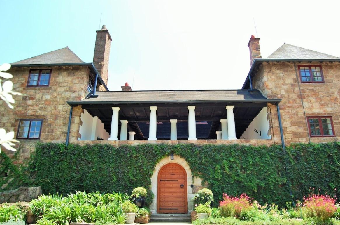
We who live in Johannesburg sometimes take for granted how very special the older suburbs on those ridges actually are – Brixton, Westcliff, Yeoville, Bellevue, Upper Houghton, Observatory, Linksfield Ridge etc. The best homes have views that stretch as far as the Magaliesberg to the north. The hard Orange Grove Quartzite proved to be an excellent building material and one has only to look at many of the heritage mansions of Westcliff, Parktown, Mountain View and Houghton to see how effectively this stone could be hewn, cut, chiselled, shaped and dressed creating those building units so beloved by Herbert Baker.
Herbert Baker's Stonehouse (The Heritage Portal)
There is another dimension and that is that suburbs and residential areas needed roads, streets, avenues and lanes to impose order on the hills of Johannesburg. Secondly the same rocky landscape needed traversing to take people and vehicular traffic from lower to high level areas and back again. The same quartz rocks created an obstacle for the road builders of the early 20th century, as the challenge was to connect those suburbs of the north to those that lay to the south. A remarkable achievement was the construction of three Johannesburg Passes and our city has the distinction of being the place where you will find the three shortest passes in South Africa. These are Stewart Drive, Munro Drive and Sylvia Pass. These special roads close to the city centre and essentially separating northern suburbs from southern suburbs and whatever lay in between are worth a tour. In fact, it is possible to take a drive up and down all three of these passes in an hour. It is a tour with a difference as one engages with geology, botany and the built environment!
All three passes feature on a website on the mountain passes of South Africa. We often think a trip to the Cape, KwaZulu Natal or Mpumalanga is needed to view spectacular scenic panoramas but right here, if you give an hour to your city, you can see it all in miniature. What was the history of these passes and for whom were they named?
Sylvia Pass
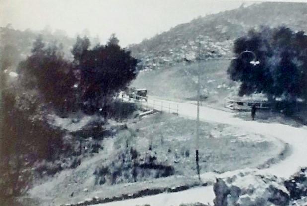
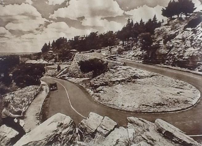
Sylvia Pass in located in Mountain View. It is the main road up the hillside taking one from Fairwood and Orange Grove to Observatory, Linksfield Ridge and Cyrildene. It is the shortest official pass in South Africa and is only about one third of a km in length and in that distance you rise about 290 metres on an “S” curve. This is the natural barrier of the ridge between the northern suburbs – Orange Grove, Norwood, Highlands North, Sydenham and beyond and the suburbs to the South such as Cyrildene, Bruma and Kensington. It is a good point to gain a sense of Johannesburg topography as the ridge runs in a westerly direction up towards Louis Botha Avenue and into Yeoville and Bellevue. The suburbs straddling the ridge are Linksfield Ridge, Mountain View, Observatory Extension and Upper Houghton. The average gradient of Sylvia pass is 1 in 9 but the max gradient is 1 in 6. When you reach the summit the elevation is 1757 metres. There are houses and walls on either side of the pass - to the left the main gracious 1920s and 1930s homes and to the right the park like grounds of vast Grace House (located at the top of the pass on Grace Road). It is a tricky road and the efforts over the years to widen the road has meant the installation of heavy steel crash barriers and pavements (which for walking are fairly narrow). It is a missed opportunity that the island at the top of Sylvia pass has not been turned into a spectacular city garden show piece.
Sylvia Pass (A city publicity brochure from 1929)
Sylvia Pass is a life giving arterial. It is the only route over the hill unless you opt for Acorn Lane two kilometres away up the Louis Botha Avenue Hill. There is traffic congestion descending down the pass in the morning after seven and then up the pass at about five in the afternoon. Locals know that this is a treacherous few hundred meters of road and know they must slow down, be patient and give themselves time to admire the engineering achievements of the road makers and the scenic setting. On the other hand, the crazy midnight inebriated idiot, coming away from the local drinking hole forgets the risk of a drive on a pass and there have been many horrendous accidents on the pass and too many lives lost.
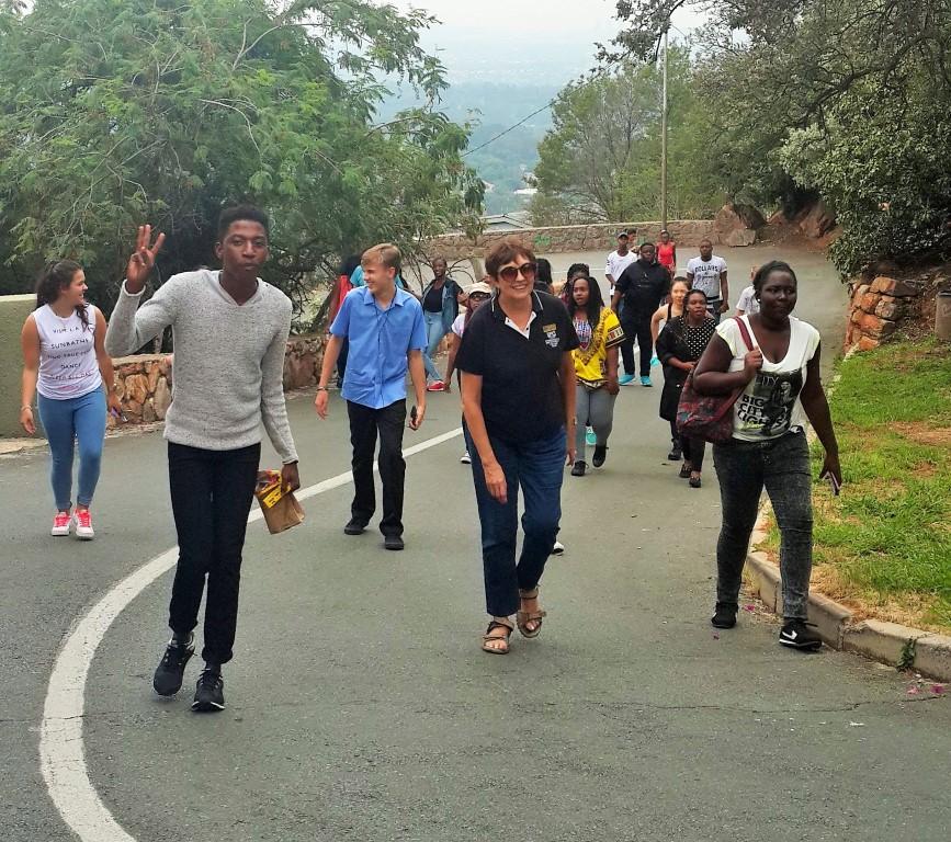
It was Messrs Kallenbach and Kennedy who purchased vast swathes of undeveloped land in Linksfield and across the ridge to the west and gave some of it to the City Council for the construction of Sylvia Pass, according to Council minutes. However, the wording in Anna Smith’s book confuses the issue. She writes, “Hermann Kallenbach built the road to his house himself because of his belief in manual labour”. However my re-examination of various sources points to Kallenbach being the rock breaker and road maker for his Kallenbach Drive but not of Sylvia Pass, as the start of Kallenbach Drive runs from the base of what is now Sylvia pass to the west and up the hill at an oblique angle.
Walking up the steep Kallenbach Drive (The Heritage Portal)
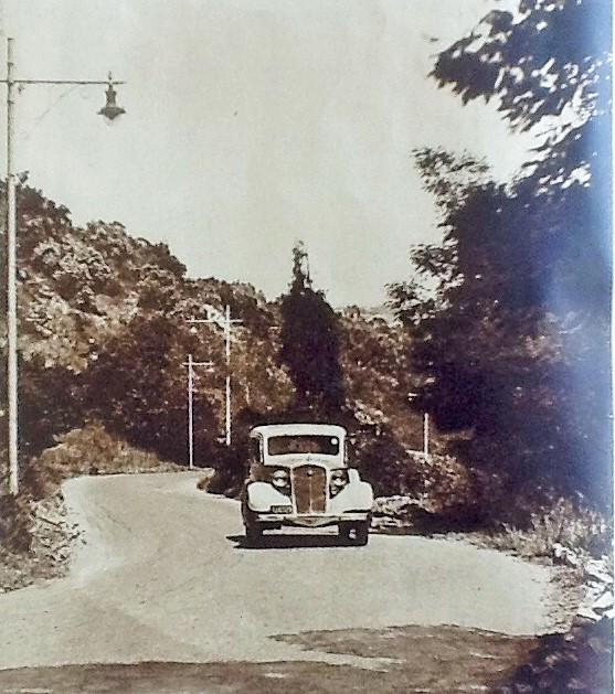
Who was Sylvia? Anna Smith quotes The Star of 25 June 1936 which records that in 1925 the Sylvia so honoured was Sylvia Witkin and in 1960 Mrs Sylvia Einstein (nee Witkin) wrote to Anna Smith personally confirming this newspaper report. However, on 1st July 1936, The Star carried another report from the formidable and well known City Engineer, E H Waugh, who rejected Sylvia Witkin as the inspiration and said he had named the pass after Sylvia Easton, the wife of the Council’s Government Surveyor, Percy Easton in 1928. The second claim was supported in 1961 by Mrs E H Waugh and in 1963 Sylvia Easton herself confirmed that she was the Sylvia. However, in 1963 when Anna Smith was conducting her research there was a third even more romantic version, with a claim from a Mrs Sylvie Kaufmann. Sylvie lived near the start of the pass and said a Councillor had admired her from afar and had named the pass for her thinking her name was Sylvia. So there are three possible Sylvias - take your pick! I would put my money on the Waugh version.
Driving up Sylvia Pass (A city publicity brochure from 1936)
The Munro Drive
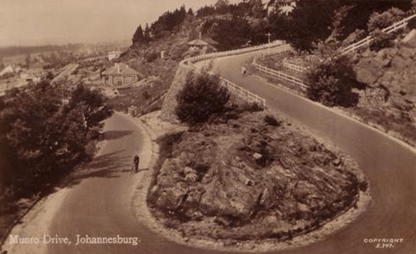
The Munro Drive, or the Munro as it is sometimes called, is a short pass that connects Lower Houghton or Houghton Estate with Upper Houghton and Yeoville. It is a scenic circuitous road, and leads from Houghton Drive in Lower Houghton to Elm St in Upper Houghton. Imagine here a “U” on its side. It is a very steep route of about 900 metres and one of the very few passes in South Africa of less than one km. There is just one hairpin curved bend. The cutting through the quartz rock was an essential part of the property development enterprises of Johannesburg Consolidated Investment Company. JCI owned the land of Houghton Estate. The name honoured John Munro, a director of JCI (source: L E Neame, City Built on Gold and Story of Johnnies 1889-1964, p 43). John Munro was a Scottish immigrant born in Tain, Ross-shire, Scotland who came to South Africa on account of his health and arrived in Johannesburg in 1892 with the Barnato Brothers (Barney and Henry). Munro was President of the Chamber of Mines in 1913, a difficult year for the mining industry as it was the strike year.
An old postcard of Munro Drive
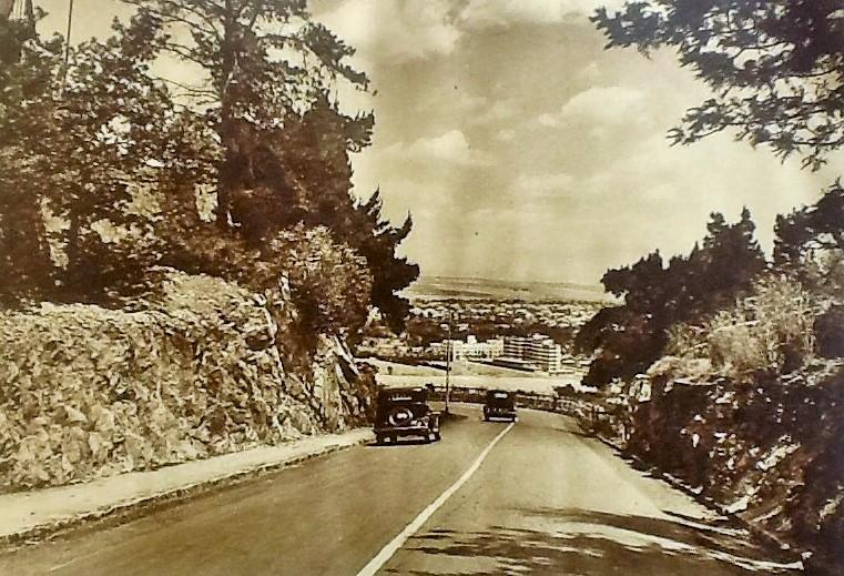
Munro Drive was completed in 1918 and one takes the road from Houghton Drive leading up the hill to the right at an incline of perhaps 30 degrees, with a steep gradient. There are houses on either side of the road and the higher one goes the more impressive the view site. As one reaches the turn to the next level, one encounters a remarkable crafted dressed stone wall cut from the local quartz. As one turns the bend and heads back up to the next level, almost bending back on the road, take a close look at the rock formations to the right – here there is an excellent view of the geology of the ridge. At the top of Munro drive there is a parking area to enable one to take in the view over all of Lower Houghton, Killarney flatland and Saxonwold. It’s a magical Johannesburg sight in October when the jacarandas are out. Better still, at midnight it is a romantic spot looking out at the city lights of the north.
Heading North down Munro Drive (A city publicity brochure from 1936)
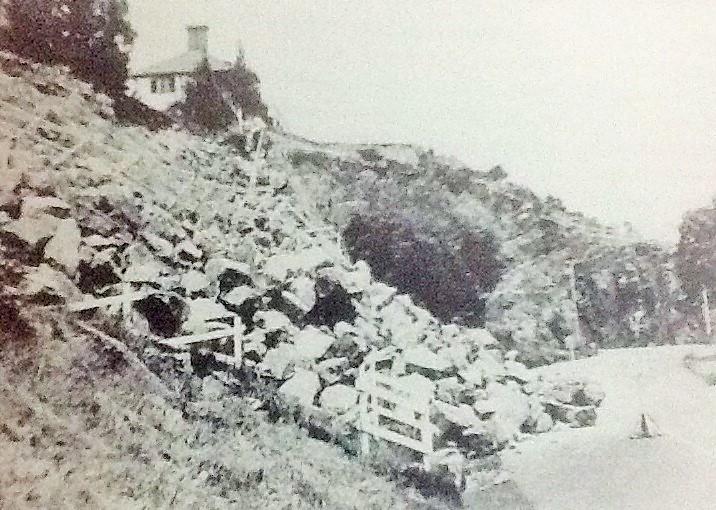
There is a twist in this tale as on 1st February 1938 the retaining wall collapsed and the road was rebuilt. It is definitely a desirable address for someone named Munro and I have always coveted a house on Munro Drive as our family starts with the advantage of the name Munro (in fact John Munro was the half brother of my husband’s grandfather, a much less distinguished and successful Munro).
Collapse of masonry retaining wall (Watershed Town)
Stewart Drive
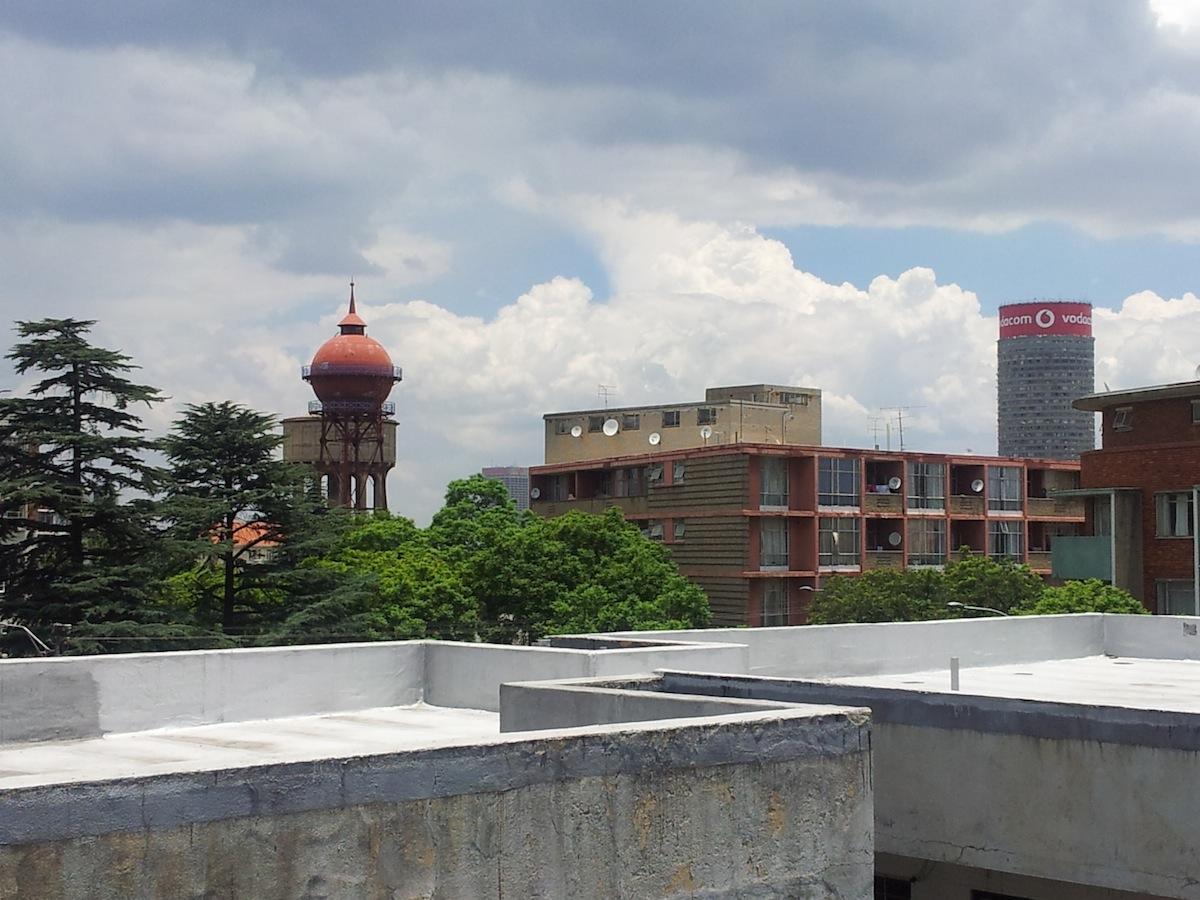
This drive is just below one of the highest spots on Johannesburg‘s series of ridges. It is a neglected but very beautiful hillside drive that connects the less affluent suburbs in the valley (Bertrams, Lorentzville, Judith’s Paarl and Fairview) to the south to the upper suburbs (also not that affluent these days, but once solidly middle class) of Yeoville, Highlands and Bellevue. This pass is more of a “double Z” pass and it is the longest of the three passes. It is on an east - west axis and it is the southern counterpart of Munro Drive to the north. The gradient is between one in six and one in ten, at some points the road is quite steep and at others the gradient eases off. At the top of the pass (i.e. descending) the access is from Jolly Street, close to Natal Street with Stewart Park on the left hand side. Stewart Drive Pass leads down to Terrace Road and into Viljoen Street. Stewart pass is within a stone’s throw of the four great water reservoirs of the Yeoville Ridge and the iconic two water towers that are landmark features of one of the highest points of elevation of the city.
Curving Stewart Drive (The Heritage Portal)
View towards the famous Yeoville Water Tower (The Heritage Portal)
Unlike the other two passes, there are no houses along Stewart Drive, although the top end of the Park is overlooked by a three storey fairly low apartment block hugging the natural rocks on the right. Take a careful look at the quartz rocks as you descend. The pass is sylvan and filled with trees and indigenous plants of the Witwatersrand. It is truly a well wooded scenic route and one of the hidden heritage treasures of Johannesburg, despite the neglect and litter. Visiting the Pass recently, the trees are rather barren looking and there must have been a fire during the winter months. There is such potential to return Stewart Drive to a magnificent asset - the hard work of cutting the road has been done and the fine stone work a legacy of the excellent Johannesburg Public Works Department is all there. The stone work reflects too the small bus shelter and water purifying plant which was located on Louis Botha Avenue, close to Tudhope Avenue (another neglected heritage structure now far gone).
Stewart Drive dates back to 1933 when construction started and was completed in 1935. Anna Smith records a Council Minute for 26 September noting the petition from ratepayers to name the “proposed connecting link road“ Stewart Drive or Road to commemorate the public work over more than quarter of a century of Mr Joseph Stewart, a local man who lived in Judith's Paarl. The decision was taken to name it Stewart Drive, although the ratepayers association of the Yeoville/Bellevue area had suggested “Bellevue Drive”. In 1937 the drive was lined with a low stone wall with open arches made of dressed quartzite quarried from the site. The stone wall is a wonderful tribute to public stone craftsmanship. Note the stone walls were not built by Italian prisoners of war. That one is an urban legend as there were no Italian prisoners of war around in the 1930s!
Looking up Stewart Drive (The Heritage Portal)
Today, most traffic is foot traffic, but it is also a taxi route. People have an energetic trudge up the hill. I am afraid I have only driven the route by car - and it is the route we take to the local hardware and builders yard, Rochas, in Bertrams. Stewart Drive is very close to Ellis Park and the Athletics stadium. I found a piece on the web written in 2012 appealing for active citizenry to make the road a safer one. It is a lonely route up the hill and considered to be unsafe for pedestrians. Despite the best efforts to reverse urban decay in the area around Bertrams and Ellis park and talk around the 2010 World Cup that the area would be rejuvenated, property prices are still low and there are too many back yard slums. The open terrain and lack of policing mean that pedestrians when walking up or down Stewart Drive fear muggings and assaults. In fact, there is one reference to Stewart Drive being nicknamed Snakes Way. This can be taken two ways: either the sobriquet reflects the serpentine snake Z shape of the pass or it refers to the problematic crime problems of assaults, thefts, muggings and even a few murders that have taken place along this pass.
The top of Stewart Drive peaks at an altitude in Bellevue at 1800 metres and drops to 1730 at the base of the pass where the houses and small blocks of flats start.
In summary, three Johannesburg passes are all worth discovering and exploring. Yes, do keep your eye on the road, but for me it’s the embedded geology, the millions of year old rocks that are the foundations of all three passes that are worth more than a second glance. Here is an opportunity to take in the distant scenic view but also put the rocks on the sides of the passes under the microscope, and have a shot at working out their origins.
Kathy Munro is an Honorary Associate Professor in the School of Architecture and Planning at the University of the Witwatersrand. She enjoyed a long career as an academic and in management at Wits University. She trained as an economic historian. She is an enthusiastic book person and has built her own somewhat eclectic book collection over 40 years. Her interests cover Africana, Johannesburg history, history, art history, travel, business and banking histories.
Comments will load below. If for any reason none appear click here for some troubleshooting tips. If you would like to post a comment and need instructions click here.

